Apple looking to improve GPS route-planning estimates
 Neil Hughes
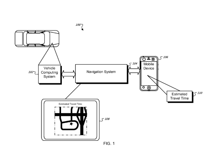
In the recently revealed U.S. patent filing, Apple describes a system for obtaining drivers' personal travel data and using it to estimate driving times. Such a system could take into account speed, time of day, location, driving patterns, season, route type and features, traffic information, road conditions and location data.
Originally filed for in 2008, the patent could save drive times and other data on the local system, and also upload it to a centralized database where the data would be shared with others.
"These features provide customized travel time estimates that take into account a user's driving habits, the characteristics of the vehicle being navigated, road conditions, seasonal conditions, traffic congestion and other factors," the patent application reads, "which cannot be accounted for by conventional statistical calculations based on data samples obtained from a test vehicle or device traveling the route."
The described system would take into consideration a plethora of factors, like stoplights and railroad crossings, and store the data on a server, time-stamped and indexed for easy access.
"The average speeds and/or average travel times for a particular route segment can be collected over a period of time," the document reads, "to provide a historical view of how the average speeds and/or travel times change for different seasons, days of the week, times of day, etc."
Since the iPhone 3G added GPS capabilities, the iPhone platform has become a viable option for those looking for map assistance. Some developers, such as AT&T and Navigon, have developed their own software to take advantage of the phone's hardware.
In June, AT&T released its GPS software solution. Developed by TeleNav and branded as AT&T Navigator, the free application requires a $9.95 monthly service subscription.
Also in June, Navigon released its own MobileNavigator for European residents. The software fetches £54.99 and includes built-in 2D and 3D maps of Europe, allowing it to function without a wireless connection.
Both are bound to face off against an upcoming offering from GPS device maker TomTom, the software for which is being developed with the help of Apple engineers. It will be sold alongside a TomTom car kit accessory, which enhances the iPhone's GPS signal through its dock connector thanks to third-party accessory support built into the iPhone SDK 3.0.
It is unclear whether a potential Apple GPS system would work in tandem with or compete against any of those systems.


 Malcolm Owen
 William Gallagher and Mike Wuerthele
 Christine McKee
 William Gallagher

 Marko Zivkovic