Nearly a year after Apple introduced its own Maps service in iOS 6 with Flyover 3D satellite views, Google is expanding its own online Maps to support similar 3D satellite imagery, with the same sorts of buckled roads and visual distortions Apple was castigated for last summer.

Google Maps 3D still a work in progress
Introducing the new Google Maps with 3D
Unlike Apple's iOS 6 Maps, which target relatively low powered mobile devices, the new 3D features in Google Maps that were introduced last week require a modern PC running a web browser with a supported version of WebGL hardware accelerated rendering.
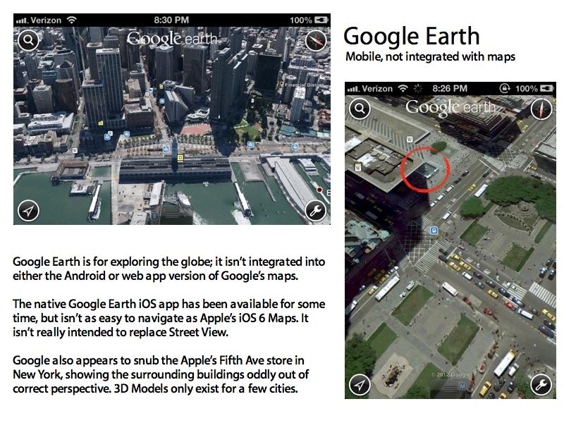
That limits Google Maps' photorealistic 3D features to users of Chrome or Firefox on a Mac or Windows PC. Mobile users will have to settle for grey 3D building models or use the increasingly outdated Google Earth, which unlike Apple Maps' Flyover feature, is not integrated with the search and directions of Google's mobile Maps apps.

This makes the new Google Maps more akin to Nokia's web-based Maps 3D. Nokia's product, which while leveraging the same technology Apple acquired to build iOS Maps' Flyover features, is also limited to the desktop web browser. A year after Apple launched iOS 6 with Flyover, neither Google nor Nokia have a similar, integrated 3D visualization feature for their own mobile platforms.
Were Google to launch a 3D Maps app for Android with similar specifications to its current desktop maps product, it would only work on about 29 percent of the platform's reported installed base of devices, just like the company's Google Now, which requires Jelly Bean 4.1.
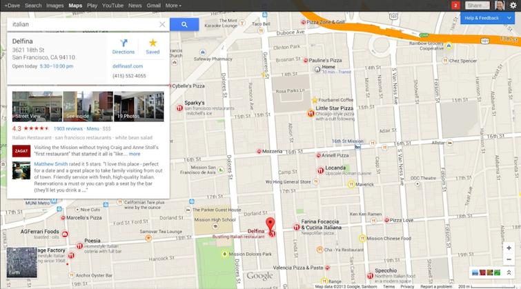
Access to the new Google Maps also requires an invitation, which links your online session to your Google account, reinforcing the company's ad-centric business model. The company's introduction to the new generation of Google Maps first highlights search features, then notes how the new product focuses on promoting businesses, "like restaurants that are recommended by your Google+ friends," as shown in the graphic below.

Source: Google
The last feature Google highlights is "amazing imagery for exploring the world," of which the company observes, "of course, no map would be complete without amazing images for exploring the world." Oddly enough, Google is pointing out that its own latest mobile maps for Android and iOS are not as "complete" as Apple's own iOS 6 Maps.
"The new carousel gathers all Google Maps imagery in one spot enabling you to fly through cities," it notes, carefully avoiding the "Flyover" term Apple introduced a year ago. And again, only on the desktop, and currently only in an invite-only beta, can Google Maps users "find the Earth view which directly integrates the beautiful 3D experience from Google Earth into the new maps."
Source: Google
Google Maps 3D messes with Manhattan
Despite its years of experience in 2D digital mapping, Google's year late, non-mobile 3D Maps product is riddled with the same kind of glitches that Apple scrambled to address after the release of its own new Maps was greeted with contempt and derision. And users don't have to scour the planet to find undulating roads and smeared buildings in remote areas.
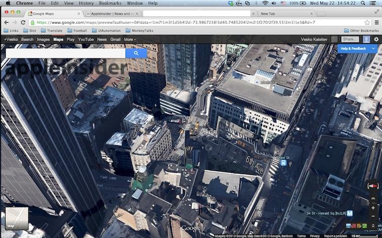
AppleInsider reader Vesko Kateliev shared Google Map's above image of Midtown Manhattan (detailed at the native resolution, below), where roads turn into waterfalls and parked cars slide up the side of of a building as if trying to escape from a rolling wave of energy twisting buildings and bulging roads into the air.
Google Maps 3D still a work in progress
Apple's Flyover representation of the same area (below) is detailed enough to see that the building Google portrays as being smeared with taxis is actually a JC Penney, and you can even make out that the adjacent billboard is an iPad commercial. Apple even does a much better job at labels for points of interest and streets. Apple also labels 6th Avenue by its official name, "Avenue of the Americas," although a search of "6th Ave" also works.
Spin around Herald Square from the opposite direction and Google Map's 3D turns its trees into a strange pillar of goo (below top), a visualization that is clearly bested by Apple's detailed Flyover view in iOS 6 Maps (below bottom).
Google Maps 3D still a work in progress
While Google does a better job with major landmarks like the Empire State Building (below top), Apple's Flyover version is both much more detailed (an impressive feat given the processing power of the iPad compared to a desktop PC) and offers a clearer representation of its surroundings (visible in the two images below it).
Google Maps 3D still a work in progress
Apple advancing its own Maps
So far, there hasn't been any embittered contempt voiced by the tech media for Google's attempts to chase Apple's Flyover coattails with a seriously flawed offering that doesn't even work on mobile devices; the sloppy release of Google's own 3D product also calls into question the company's hubris in fueling smear campaigns against Apple's own mapping product last fall.
Apple has been focused on enhancing its own product, meeting the needs of developers and hiring new staff to work on the project.
Additional advancement of Maps for iOS 7, and perhaps on the Mac in OS X 10.9, is expected to be announced next month at the company's Worldwide Developer Conference.
Google has apparently felt the pinch of losing its default position as the Maps app iOS users see on their Home screen, as just last month the company's chair and former Apple board member Eric Schmidt said, "we would still really like them to use our maps" as the default choice in iOS.
"It would be easy for them to take the app in the store and put it as their basic one," he observed.