While most mobile devices rely on GPS for mapping and navigation, the system only works outdoors and in range of satellite timing signals. However, new technology from Apple could extend accurate positioning indoors without need for additional hardware aside from existing Wi-Fi infrastructure.
A patent granted to Apple by the U.S. Patent and Trademark Office on Tuesday describes a robust system that combines GPS, Wi-Fi access points and onboard location databases to provide mobile devices accurate positioning data in nearly any environment.
According to Apple's U.S. Patent No. 8,700,060 for "Determining a location of a mobile device using a location database," the method employs location estimation through the successful communication with one or multiple Wi-Fi access points.
By calculating a number of factors, including access point filtering, hardware communication range and so-called "presence areas," a mobile device can narrow down its position on a map with relative precision. This includes products without GPS receivers.
One of the first steps in Apple's patent calls for a location-aware device or devices (with GPS capabilities) to transmit their position to a first Wi-Fi access point, which in turn relays the information to a server-based location system. From this data, the system can then estimate the approximate location, or "presence areas," of other devices within the communication range of the access point.

Source: USPTO
To calculate these presence areas, the system may use any number of analyses including an averaging of geographic locations based on location-aware mobile devices, signal strength of a given access point and surrounding building architecture, among other variables. Presence areas may be selected in a multi-pass process by filtering out potentials based on "popularity, stability, longevity, and freshness."
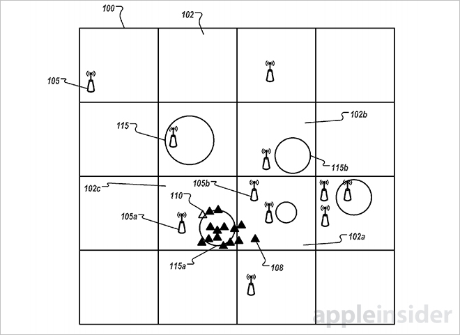
Loaded with data, the system can plot out connected mobile devices in cells on a geographic grid. Each cell acts as a container for presence areas and corresponding access points. As seen in the image above, location-aware devices are represented as black triangles that are within or nearby presence areas denoted by circles.
One way a mobile device can calculate its location is by detecting multiple presence areas and averaging distance from those close by, while discarding data from "outliers" farthest away from a given position. Following processing, the device can then display its average location on a mapping app.
Alternatively, an access point can send position information about other access points nearby, including only those that are within a mobile device's area of interest. This method of filtering is also used to approximate margin of error, which is denoted by a radius or radii extending from a focal point within a presence area.
In addition, Apple's method accounts for three-dimensional space by taking into consideration altitude data from devices supporting such GPS metrics.
From left: Multi-pass analysis, multi-pass analysis with outlier, and 3D positioning grid.
Tuesday's patent is similar to technology created by "indoor GPS" firm WifiSLAM, which Apple purchased in March 2013 for about $20 million. WifiSLAM's system relies largely on Wi-Fi signals to accurately position mobile devices while indoors and does not require GPS to operate.
Apple's patent for a Wi-Fi-based positioning system was first filed for in 2010 and credits Ronald K. Huang as its inventor.
