 Roger Fingas
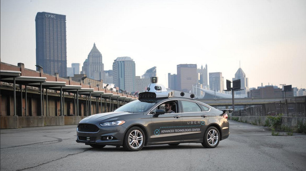
App-based ridesharing service Uber is using a fleet of vehicles to collect street-level mapping data, with the goal of improving routing and ETA data, a company spokesperson confirmed on Monday.
Contractors have been driving the cars around cities for the past few months to capture 3D images of streets, BuzzFeed News reported. Uber currently relies on a mix of Google Maps data and its own routing algorithms, but the spokesperson suggested that the new data could make it easier for drivers to avoid congested streets and intersections.
While the mapping vehicles have been spotted in places as remote as Florence, Kentucky, some of them have been touring areas near Uber's Advanced Technology Centers with the University of Arizona and Carnegie Mellon University in Pittsburgh.
The company acquired Bing mapping assets and 100 workers from Microsoft in June, but is using proprietary technology in the mapping vehicles, BuzzFeed noted.
In the long run, Uber could use the data as a foundation for self-driving technology. CEO Travis Kalanick has openly expressed interest in autonomous cars, which could result in a future where customers never interact with a human during rides.
Apple is also believed to be working on self-driving technology, and even its own car, though the first model might lack self-driving features. The company has also been driving its own mapping vehicles around the world — while speculation initially revolved around autonomous systems, Apple eventually stated that the data would appear "in future Apple Maps updates."


 Amber Neely
 Mike Wuerthele
 William Gallagher


 Andrew Orr
 Wesley Hilliard


5 Comments
It would be interesting to know mapping companies policy on repeating their surveys. A year ago I reported about 100 missing homes where I live to both Apple and Google. Apple corrected this for their aerial maps but Google did nothing. I have this month reported the error to Google again. I think their aerial photos for my area date from 5 years ago.
While the mapping vehicles have been spotted in places as remote as Florence, Kentucky...
I wouldn't call Florence, KY remote.
Its well within the Metro Cincinnati area of over 2 million people, and maybe 15 or 20 minutes from downtown.
[quote name="AppleInsider" url="/t/189618/uber-deploys-fleet-of-mapping-cars-to-collect-street-level-imaging-data#post_2793004"] In the long run, Uber could use the data as a foundation for self-driving technology. CEO Travis Kalanick has openly expressed interest in autonomous cars, which could result in a future where customers never interact with a human during rides.[/quote] A few weeks back there were stories of a possible tie-in between Uber and Tesla, rumors that were not denied (or confirmed) by Mr Musk during an investor call.
I happened to see one of them the other day in Kansas City.
I saw one in Norfolk VA