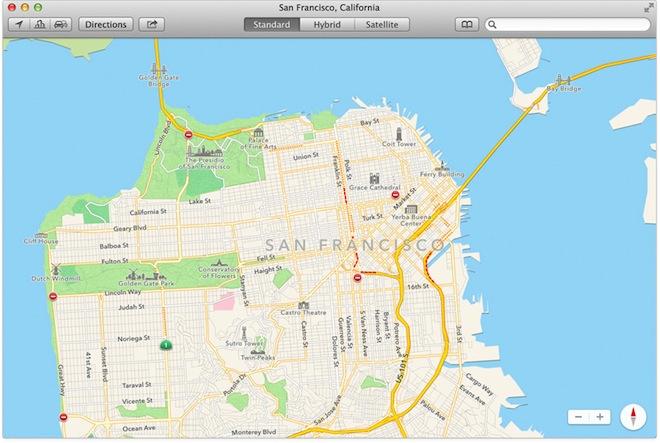
Apple has brought its iOS Maps to OS X Mavericks, adding enhanced error reporting tools to leverage crowdsourcing in order to improve its mapping service, search results, location information and directions.

Source: Apple
The upcoming release of OS X Mavericks brings Apple's Maps to the Mac desktop in the form of a native app, giving it an enormous advantage over the web-only mapping services offered by Google, Nokia and others.
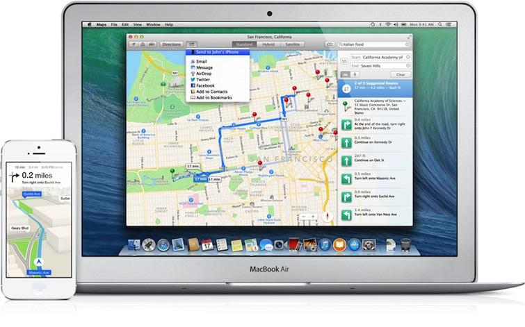
As a native Cocoa app, OS X Maverick Maps is blazing fast, supports familiar multitouch gestures like pinch to zoom, directly integrates with Contacts, syncs location Bookmarks with iCloud and can share locations and directions using standard Share Sheets via email, iMessage, nearby users with AirDrop or to Twitter and Facebook.
One of the primary notable features in OS X's new Maps app, as demonstrated by Apple's head of software engineering Craig Federighi at WWDC earlier this month, is the ability to plan a trip at home and then forward the route, via iCloud, directly to your iPhone for turn by turn directions in your car (below).

Source: Apple
Reporting maps errors made easier on the big screen
But another clear intent of putting Maps on the Mac involves leveraging lots of eyeballs to identify and report errors, something Apple has made easier to discover and do on the Mac when compared to smaller-screened mobile devices.
Apple has always included a way to "report a problem" in iOS 6 Maps, but because it does so in the context of Yelp local search information, it's not readily obvious that this button is for reporting map errors rather than just filing a grievance against a business or Yelp's data (below).
Additionally, once a user decides to report an issue, whether related to the contact information of a particular point of interest, an incorrect pin location or a nonexistent search result, the small size of a mobile device's screen also complicates this task.
On MacBook or Cinema Display, it's much easier to report an issue. Users can even open another window to perform a parallel search for the correct data of a particular location.
Where's the fire (station)?
Apple has also improved its Maps issue reporting process, a necessary function for a tool that depicts the entire globe and all of the changes, construction and location updates occurring by the millions every day.
One example of a significant, recent map change involves Fire Station 1, which was recently moved out of the way for an expansion of the San Francisco Museum of Modern Art.
The museum contributed $10 million dollars to design and build a new station a couple blocks away, which was just completed a few months ago.
Apple Maps still shows the old location on Howard Street, information that's also incorrect on Yelp, where Apple gets the data. The change is recent enough that it doesn't yet even show up on the city's fire station map.
Source: Google Maps
Google Maps for iPhone, the current web version of Google Maps, and the new vector-based WebGL version of Google Maps that's now in beta (above) all pinpoint the station at its new location, at least if you explicitly search for "Fire Station 1." If you just search for "fire station," Google Maps shows you several surrounding locations but omits the new one.
All three versions also portray the site with outdated Street Views (below) that show (mostly obscured by trees at the street level) the previous building: the site of an illegal sweatshop the Feds shut down a decade ago.
Source: Google Maps
In Google's iOS Maps app (below top), you can see Street Views or, in standard satellite mode, you can see the building's roof. In the new web-only WebGL Google Maps beta, you can also see Google's Flyover-like view, although unlike Apple Maps, you can only view Google's 3D satellite images from fixed angles and the images are much lower quality.
Source: Google Maps
Source: Google Maps
Apple Maps also shows the old building on the new site (below). While Apple doesn't have Google's Street View images, it does pull street level, interior and other site relevant photos from Yelp and other sources for selected locations.
Source: Apple
In Flyover, you can also zoom in and around a 3D modeled satellite view of the old (below) and new sites, but as with Google's static satellite and Street Views, it's often hard to know how old the satellite images are and equally impossible to correct them on your own. You can, however, submit a report flagging an error, as described on the next page.
Source: Apple
Reporting a problem
With the Mac's increased screen size and windowing display, its now easier to report a problem in Maps. Apple presents "Report a Problem" in Maps application menu bar as well as in the detail panel of a selected location (below).
Reporting an issue presents a sheet featuring a drop down menu including "place does not exist," allowing you to simply note that the location has closed or enter a descriptive comment (below).
You can also select "information is incorrect" and suggest the correct data, which appears in red (below).
You can report a pin placed at a incorrect location, and drag it to the correct spot.
These are all things you can already report in iOS 6 Maps, although they're easier to perform on the Mac.
Reporting another problem
The new OS X Mavericks Map app also offers expanded, detailed issue reporting related to satellite images, labels, search and directions. For example, you can report a "problem with satellite image," noting that it is outdated, poor quality or enter a more specific problem (below) as well as positioning the map to show the problem you describe.
You can report an incorrectly labeled street or other feature (below), suggesting your own alternative.
You can also report an incorrect search result, selecting a particular pin as an "unexpected result," or noting that the results of a search selected the wrong pin.
Additionally, you can report a problem with the directions provided, specifying that the directions led to the wrong place, took longer than estimated, involved traffic or a closed road, or comment on another problem. You can even specify a problem with a specific step along the route, noting that it went the wrong way, involved a prohibited turn, a closed road or some other issue.
Apple's ambitious plans for Maps
OS X Maverick's new native Maps app and expanded reporting options demonstrate Apple's interest in rapidly improving upon the mapping service it launched last summer, when it debuted iOS 6 Maps using its own new 2D and 3D map and satellite visualizations, points of interest and directions with traffic information.
Apple was clearly aiming to free itself from dependance upon Google, which was already threatening to leverage its own Maps+Navigation as an Android exclusive over iOS the same way Microsoft used the popularity of its Office suite to entice Mac users to adopt Windows in the mid 1990s, similarly using exclusive features and better performance on its own platform to woo defection.
Rather than trying to replicate the existing Google Maps, Apple jumped upon the opportunity to introduce its own modern mapping service leveraging vector-based maps to enable enhanced offline use, as well as technology acquired with C3 to deliver 3D Flyover views.
Apple also partnered with a variety of third parties including Waze, TomTom for maps, DigitalGlobe for satellite imagery, reviews and points of interest from Yelp, and data supplied by NASA, European Space Agency, the U.S. Geological Survey and other American, Canadian, British and Australian government agencies. Compiling all of this information together on a global scale for iOS 6 Maps' debut last summer proved to be a massive undertaking.
Apple Maps immediately branded a failure, by Google
Despite years of coordinated work on Maps to replace Google's service, Apple's mapping efforts were often negatively reviewed for depicting flawed Flyover images, presenting incorrect place labels and delivering inferior or at least different search results.
When ExtremeTech compiled its five "biggest tech failures" of 2012, it listed Apple Maps alongside HP's $8.8 billion Autonomy disaster, Google's Nexus Q flop, Microsoft's Metro-rebranding that dragged down both Windows Phone and Windows 8, and BlackBerry's entire year of corporate collapse.
Search Google for "Apple Maps" and the first suggestion is "fail," a treatment that isn't applied to even massive technology boondoggles such as Microsoft's Zune, Palm webOS, or Google's own Android 3.0 Honeycomb, Nexus Q or Buzz.
Last winter, Google's Motorola even launched a misleading social network campaign using hashtag "#iLost" to denigrate Apple Maps.
Of course, a major reason behind the search engine's depiction of Apple Maps as a failure may likely be that the iOS 6 introduction of Apple Maps shifted Google Maps from getting nearly all iOS-related data related to millions of affluent users' maps, directions, traffic and location requests into the position of being an optionally downloaded, third party app that now claims, according to Onavo, only an estimated 34 percent of the iOS navigation app market.
Apple's move has also stripped Google of getting third party app developers' mapping referrals by default, making Onavo's ranking (based on users' active app use patterns) an optimistically conservative view of Google's Skyhooking at the hands of Apple Maps.
Given that 96 percent of the active installed base of iOS users have migrated to iOS 6, it's no wonder why Google is not happy about Apple launching its own maps at the expense of its own.
With Apple now putting its Maps on the desktop of 72 million Mac users, combined with easier to use issue reporting tools, Google will increasingly face competition with a more sophisticated product from Apple even as it stands to lose even more location-based web search traffic, particularly the data pertaining to a market segment covering 90 percent of PCs that sell for more than $1000.