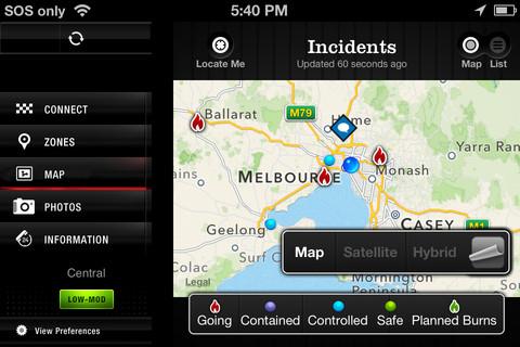
Officials in Victoria, Australia are pointing at Apple's much-maligned Maps App for causing dangerous inaccuracies in a bushfire information app, saying that problems with the mapping service make it difficult to determine exactly where fires are when alarms are received.
The Sydney Morning Herald reports that the Country Fire Authority in Victoria is blaming Apple's mapping data for errors in its own FireReady bushfire information app. Officials say that they were forced to rely on Apple Maps for FireReady, which is available on the iPhone and the iPad.
"Users report that towns are located on their maps at the centre of the district rather than on the actual township itself," said one CFA spokesperson. Another official added that CFA has already received numerous complaints regarding errors in the FireReady app.
"This makes it very difficult to quickly determine the location of fires once alarm calls are being received," the spokesman said. "This creates potentially dangerous situations and delays to activate phone trees if required."
According to CFA, attempts to contact Apple have been met with suggestions to report inaccuracies through a function provided in the Apple Maps app. CFA has urged people not to rely solely on one source for emergency information and pointed users to its website, which relies on Google Maps.
Apple's Maps app has been a sore point for the company since its introduction with the release of iOS 6. Its occasionally incomplete or inaccurate data has led officials in Australia to advise against relying on it in the past. The Cupertino tech giant's troubles in the mapping sector have been cause for light ribbing from Google, which Apple dropped as a mapping solution for Apple Maps.
 Kevin Bostic





 Malcolm Owen
 Andrew O'Hara
 William Gallagher





29 Comments
Use the Google Maps app instead. Problem solved.
Of course--and if they used Google or something else, there would be errors too. Of course, the media has us focused on them right now. Meanwhile the police are warning people that Google's own maps in Australia [URL=http://news.cnet.com/8301-1023_3-57558777-93/police-google-maps-giving-dangerous-directions-too/]are dangerous[/URL]. It's almost as though no map system is perfect, but with an Apple logo, the errors are suddenly worth caring about :p I'd love to see some data (per country, since they vary so much) on Google errors vs. Apple ( Waze & TomTom) errors. [I]Data.[/I] NOT anecdotes and folk wisdom. What kinds of errors, how many, how serious, how often? The only data I've actually seen, for [URL=http://blog.tabini.ca/2012/09/old-maps-vs-new-maps/]Canada[/URL] and [URL=http://appleinsider.com/articles/12/09/25/ridiculed_in_the_west_apples_ios_6_maps_are_instead_praised_in_china]China[/URL], has been in Apple's favor. (In Canada, Google returns results instead of nothing more of the time... making you think it "knows more places" than Apple... but Google's results are too often miles off! Google's results are useless so often that Apple is actually the one returning more results that are [I]correct[/I]. Too many of Google's results are useless--if not dangerous--errors. For instance, I'd rather get 5 truly accurate hits out of 10, than 9 hits of which 7 are wrong. You'd almost think Apple values quality while Google values keeping you on their site as long as possible no matter what the reason...) So what's the reality? Is Google's info perfect? I've personally run into locations in the US that Google couldn't find and Apple could. Major public facilities, no less. I'm sure the reverse is true too. Even $2000 GPS systems built into cars have errors. But this is for sure: Apple does NOT require app makers to use their maps. I have tons of apps that use other map sources: Navigon MyRegion, MotionX GPS, Waze, MapQuest, WeatherBug, Dark Sky, Google Earth, and of course, Google Maps. "Officials say that they were forced to rely on Apple Maps for FireReady" Hmmm... not by Apple, they weren't. Apple maps certainly integrate into the OS nicely, but I don't see how that's needed here. It's not like people are going to want URLs clicked on the web to launch FireReady for driving directions, or something. And if something is life and death, using ANY remote Internet data service is risky and needs a disclaimer. That's life.
Use the Google Maps app instead. Problem solved.
Um google maps had the same issue of sending people to a nature reserve in australia just like apples map app, it was publicized in australia right after the first apple maps incident. Google maps has a lot of errors too it just does not get the exposure apple does. I have experience a lot of those errors in google maps myself over the years.
Heres a link to googles map problems in australia as reported by there police: http://pocketnow.com/2012/12/15/australian-police-warns-google-maps
Turns out that both google and apple relied on the same local mapping firm for there map systems in that area of australia. So both had the same issue.
"Users report that towns are located on their maps at the centre of the district rather than on the actual township itself," said one CFA spokesperson. Another official added that CFA has already received numerous complaints regarding errors in the FireReady app.
"This makes it very difficult to quickly determine the location of fires once alarm calls are being received," the spokesman said. "This creates potentially dangerous situations and delays to activate phone trees if required."
According to CFA, attempts to contact Apple have been met with suggestions to report inaccuracies through a function provided in the Apple Maps app. CFA has urged people not to rely solely on one source for emergency information and pointed users to its website, which relies on Google Maps.
Why do they say they were "forced" to use Apple maps?
Why didn't they simply use a different map.
There are plenty of apps with non-Apple map data (that I wish I could use Apple maps with).