 Daniel Eran Dilger
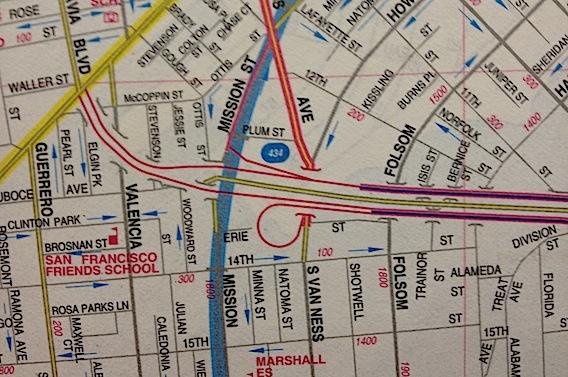
The first feature of Apple's new Maps is perhaps its strongest: its presentation of 2D and 3D road maps and satellite images. This is a major leap over how the previous iOS 5 Maps work, although there are still reasons you might want to consult other iOS apps for map information.
5: Routing & traffic
Apple's technology vs alternative maps: Maps and visualizations
This series comparing Apple's new iOS 6 Maps with other alternatives was
Providing useful maps and visualizations (this initial segment), finding transit routes, correctly labeling useful landmarks and businesses, searching for locations and finding directions between them (and through traffic).
The challengers include iOS 5's old Maps powered by Google; existing web app map services by Google and Nokia (available for free to iOS 6 users); the TomTom GPS app; and alternative mapping apps from Microsoft's Bing, MapQuest, OpenMaps, and Waze.
Vector map features
Apple's new Maps are a huge leap over iOS 5 maps in pure technology: the use of vector maps (mathematically described, resolution independent map information rather than static bitmapped pictures of map tiles) enables fast, sophisticated navigation of 2D and 3D views with fluid panning, rotation and perspective, in stark contrast to the flat, static map images provided by Apple's previous version of the app.
Using vectors also results in much less data use (an estimated 80 percent less), as your iPhone can download large areas of maps faster (eating up less of your data plan and battery).
As noted earlier, this efficiency enables iOS 6 Maps users to go offline and remain navigating with usable maps over a much wider area than the old version of Maps in iOS 5. Google's own Maps for Android also uses vectors, but it doesn't support the same scope of "configuration free" offline use as Apple' new Maps app.
Dynamic 2D presentation
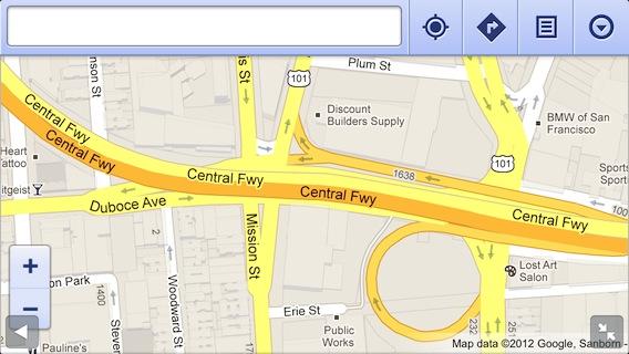
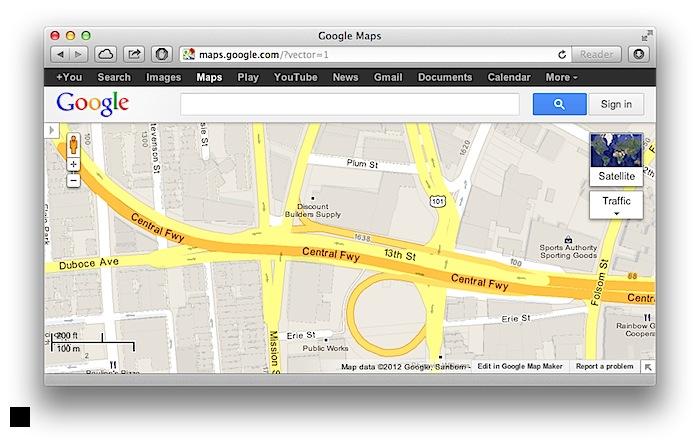
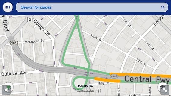
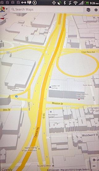
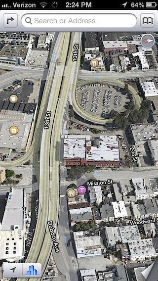
In addition to better handling of offline maps, Apple uses its new vector maps to progressively reveal detail on the map, keeping things simple until you zoom in. An example of this progressive, dynamic information display is how the Central Freeway is depicted in the middle of San Francisco. First, compare how the official AAA road map has rendered this area on paper for decades (below).
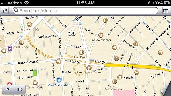
Zoomed out, iOS 6 Maps shows you the route of the freeway, but emphasizes the busy street grid of the thoroughfares Van Ness, Mission and Valencia, portraying their paths on top of the overhead freeway (below). It's also clearly apparent that there is a surface road (13th Street) running underneath the length of the freeway, something that isn't as clear in the traditional paper road map above. Apple also correctly depicts McCoppin Street as ending, rather than running underneath the freeway, as AAA's paper map does.
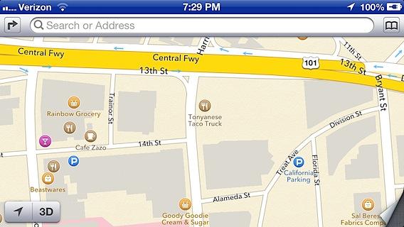
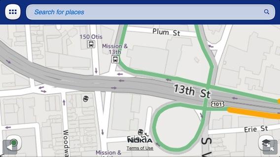
Zoom in and the freeway itself is highlighted, with clear routes for all of its ramps (below). Apple's Maps intelligently decide when to highlight the freeway and when to focus attention on the streets that run under it; other parts of the same freeway that run over less important side streets don't do this shifting of views.

This intelligent, dynamic shifting of how roads are portrayed at different zoom levels also makes the direction of one way streets clearer. Apple similarly doesn't show building outlines until you're zoomed in to the level of seeing about 6 blocks (below, buildings are just beginning to fade in at this 2D zoom level).
It's not clear if this design decision was aimed at delivering map clarity or faster performance. However, it also tends to make Apple's maps look less detailed than Google's maps, which show subtle building outlines and lot markings even when zoomed out far further.
Regardless of one's personal preferences for showing useful detail vs. distracting clutter in mapping depictions, there's clearly a lot of thought that went into Apple's dynamic new Maps that isn't seen in competing products. Contrast the depictions of other mobile map vendors on the next page.
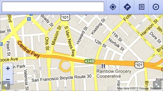
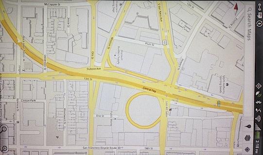
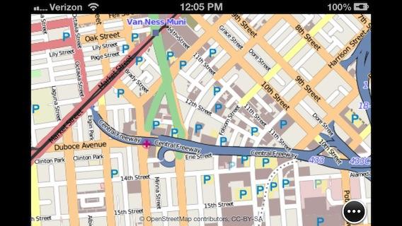
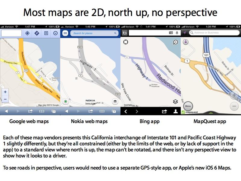
Google (in iOS 5 Maps, or via the web) also depicts streets differently as you zoom in, but at fixed zoom layers of bitmaps that sometimes show roadways as a jumble of tube segments that appear to randomly turn or end, when they do no such thing.

Google draws lot outlines within blocks at much lower zoom levels, resulting in a more detailed looking map. Even when at a zoom level that properly renders the paths of streets, however, Google's Maps often gloss over lots of street detail, with depictions that can appear less articulate than a classic paper map, rather than clearer and more informative.
Zooming in further, Google's bitmaps on the web and iOS 5 Maps also show simple 2D building outlines earlier than Apple's iOS 6 Maps. If you're accustomed to Google's Maps (as nearly all iOS users are), Apple's refusal to show building detail until zoomed in very close can be both annoying and give the impression that Apple's maps are too simple and bereft of detail.
It's arguable whether it's more important to see building detail or clear road detail. Apple appears to be focused on road clarity, while Google tilts toward showing more in the way of detailed building outlines and the lot boundaries within blocks.
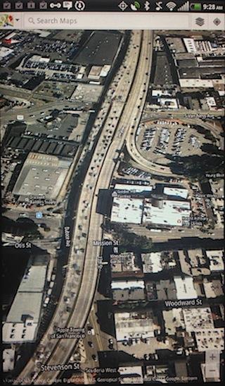
Google's native Maps+Navigation app for Android (photographed here running on a 7 inch tablet) also uses vector images, but still doesn't seem do as good of a job of representing complex intersections as Apple's new maps.
The vector maps visible from Google's Android app are virtually identical to Google's experimental vector-based WebGL maps (currently viewable only on the desktop). It's hard to argue that these are in the same league as Apple's new 2D vector maps in iOS 6.
AOL's MapQuest maps (via its iOS app) also zoom through layers of bitmaps, but they seem to do a much better job of scaling detail up and down compared to Google. Like Google, MapQuest shows lot and building outlines sooner than Apple, but it also shows good road detail.
The app is optimized to search for local listings from a series of sources (local search will be discussed later), but its ad-driven user interface also takes up a lot of the available screen on an iPhone. It also doesn't take advantage of Apple's two year old Retina Display, nor does the app support iPhone 5's larger screen yet.


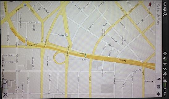
Nokia's web app shows a very simplified set of paths with limited detail that appears suited to use on a feature phone. Details such as whether McCoppin Street goes under the freeway are left rather ambiguous.
As a web app, it can automatically take advantage of Apple's full screen mode in Safari and support the iPhone 5's larger screen. Nokia's servers don't take advantage of high resolution Retina Displays, however.
The web app isn't very useful for browsing around to navigate, and isn't really very appealing to look at, but Nokia's web site can be useful for finding locations and getting intelligent routing instructions, as we address later.
Microsoft's Bing maps are also pretty basic. While it partners with Nokia for its maps, Microsoft presents Bing maps slightly differently. Here, similarly zoomed in, Bing shows oddly confusing simplifications so drastic it appears the Erie alleyway connects to the freeway onramp (below). Like AOL's app, there's no support for Retina Display or iPhone 5.


OpenMaps are so awful we won't waste too much time detailing how bad the app is (below). Yahoo's search app doesn't have its own maps; as noted earlier, it uses Apple's maps to present its Local search results but otherwise uses Nokia's map images, albeit not as well as Nokia itself does.

Web maps from Google and Nokia are useful for some tasks where they excel, but can't hold a candle to Apple's overall native app experience. Other iOS mapping apps provide specialized features suited to location searches (like MapQuest), driving directions (GPS apps) or the "social GPS" features of Waze, all of which we'll examine in greater detail later.
2D alternatives for iOS 6 users
In terms of visual 2D representations and technology, Apple's new iOS 6 Maps (below) comes across as a clear winner. The clarity of Apple's new maps demonstrate a significant leap over the existing state of the art in mobile maps, something that most reviews seemed unable to observe as they focused exclusively upon areas where Apple doesn't provide useful maps coverage (Google currently returns over 2.5 million search results for "falkland island iOS 6," for example).
At the same time, Apple's list of 181 countries supported with 2D Maps and satellite images is simply not accurate.
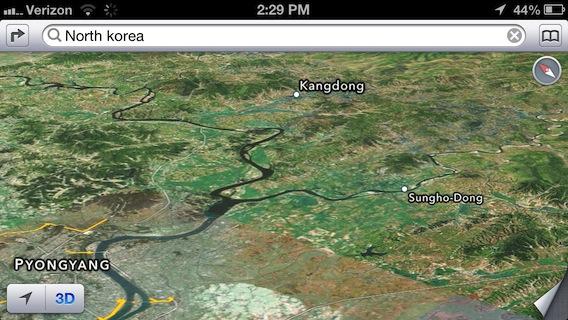
For example, Albania and Serbia are listed, but both countries lack even the most basic street maps in even their major cities (despite having detailed satellite images down to the street level). On the other hand, Côte d'Ivoire and North Korea are not listed, even though the former shows many primary roads and both have detailed satellite images.
Google claims maps for 209 countries (although 22 are noted "major roads only"), and Nokia says it has "superior maps for nearly 200". Both vendors supply fairly detailed road maps across Africa and remote islands where Apple's fall down completely.
If you're navigating in an area where Apple doesn't supply useful maps, there are a number of options, ranging from native apps to web sites. But most of these (including the web apps of Google and Nokia) depend on data service, which is likely to be missing or expensive in those areas. That makes a dedicated GPS app with pre-loaded maps a more likely solution for travelers. The App Store has a variety of other apps that also provide offline road maps for specific areas.
"Standard" 2D maps aren't the only useful way to peruse locations. There are also 2D maps in perspective, 2D aerial and street view images and 3D model and photorealistic satellite views, each of which presents Apple's iOS 6 Maps with a different set of competition.
Standard 3D Perspective views
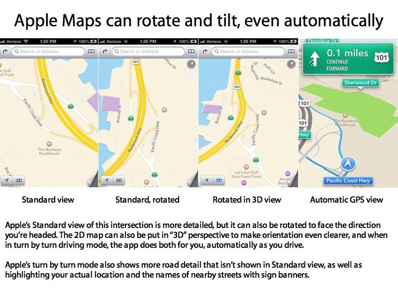
Turn on "3D" in standard view, and Apple puts the map into perspective view with building and landmark models that erupt from the land, where these are available. This view does not show topographical changes in the landscape.
This was never supported in iOS 5 Maps, although it is similar to Google's "3D" building model perspective view on Android, which is supported in "over 100 cities." Nokia is expected to similarly add 3D building models in Windows Phone 8. Neither firm supports any sort of perspective view in its web app. Some GPS apps do show 3D models in their turn by turn instructions.
Apple calls this feature "3D Buildings in Navigation" (as opposed to its photorealistic Flyover) and currently says it is supported in just 23 US cities (Flyover is, counterintuitively, available in more cities).
Outside of these cities with building models (which also show up in 2D and 3D turn by turn directions), 3D Standard mode is essentially a tilted perspective of the map. Apple separately provides 2D building outlines for most major cities internationally, but when put in "3D mode," these remain as flat as the rest of the map.
Apple's flat, 2D building outlines are similar to those shown by Nokia and MapQuest and what Google shows on the map in both iOS 5 Maps and via the web, although again, these other companies opt to show this type of detail earlier at further out zoom levels.
Apple's new iOS 6 Maps is unique in offering to depict 2D maps in perspective view on iOS. Google does show a similar perspective view in its Android app, but just as with its 2D maps, it does not deliver the same level of clarity in roads (below), but does offer more detail in its building models. On both platforms, you can freely rotate and zoom in on the map in this perspective view.
So what's the point of putting 2D maps in perspective, particularly if you're somewhere other than the few places Apple currently supports with "3D Buildings in Navigation"?
Being able to rotate the map and put it into 3D perspective can help when navigating complex intersections or simply orientating yourself on the map, such as at this freeway intersection, below.
The map options above don't offer map rotation or perspective views, which are in general a feature of vector maps, like those used in GPS style apps (such as Waze, pictured below)

Apple's support for vector maps in the new iOS 6 Maps does let you rotate and put the standard map in 3D perspective, and will even set up views for you automatically when in turn by turn directions mode. Note that Apple's automatic turn by turn maps are even more detailed. This indicates Apple is purposely simplifying its Standard maps to make them easier to read.
Apple's new iOS 6 Maps don't cover all the features of a dedicated GPS app, but is comparable in turn by turn navigation features to the mobile apps of Google and Nokia, as we'll look at in more detail later in the segment on driving directions. If Apple's navigation style is too simple for your tastes, you'll be happy to find that Apple's iOS App Store offers the largest selection of mobile GPS app alternatives, ranging from free to subscription to paid versions.
Views from the street
Sometimes a standard map (even with 3D models of buildings) isn't enough to visualize a location or find your bearings. In some cases, an abstract map representation is less useful than seeing an actual photograph of what an area looks like, taken either from the street or from overhead. In many cases, both types of imagery can be used together to orient oneself or navigate a complex intersection.
In iOS 5, Apple provided both "satellite" images (often actually taken by airplanes) and Street View vantage points for specific locations, both from Google servers. Google has spent years collecting Street View panoramas every few feet along most major roads.
While no longer presented in iOS 6 Maps, Google's Street View is still accessible to iOS 6 users, both via third party apps and from Google's own web app. Rather than attempting to duplicate Google's Street View, Apple's new Maps provide a different kind of photorealistic perspective.
3D Satellite views
In iOS 6, Apple presents its own "top down" satellite images. In place of street level views, Apple developed technology (based on its acquisition of C3) to take existing satellite data and build 3D topographical images out of it.
When you turn on "3D" with Satellite images selected, you actually get a topographical map, with a greater range of perspective possible compared to the Standard road map. This works pretty well for landscapes, making Apple's 3D Satellite views an interesting way to compare the flat perspective standard view with how the earth actually looks (below).
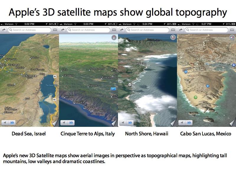
Using this sophisticated software to create a 3D perspective for existing satellite images technically works anywhere, even in North Korea.
In cities however, Apple's automated 3D satellite perspective images appear relatively flat, just like the flat satellite images Google supplies in its Android app when looking at street perspectives. In some places, Apple's 3D rendering software depicts structures or landscapes incorrectly.
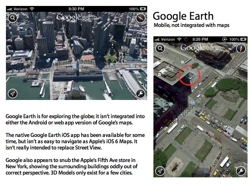
3D Flyover views
To improve upon this, Apple acquired C3, the company Nokia partnered with to deliver its experimental Maps 3D project. Similar in some respects to Google Earth, the technology builds detailed 3D maps of buildings and other man-made structures, a feature Apple brands "Flyover." Unlike its competitors, Apple integrated its Flyover feature directly into the mobile Maps app as a feature of the Satellite layer.
Turn on satellite images and you can activate Flyover (anywhere that "3D" is replaced with Apple's buildings icon) to get an even better real-world depiction of what things look like at closer zoom levels. This was also never supported in iOS 5 Maps.
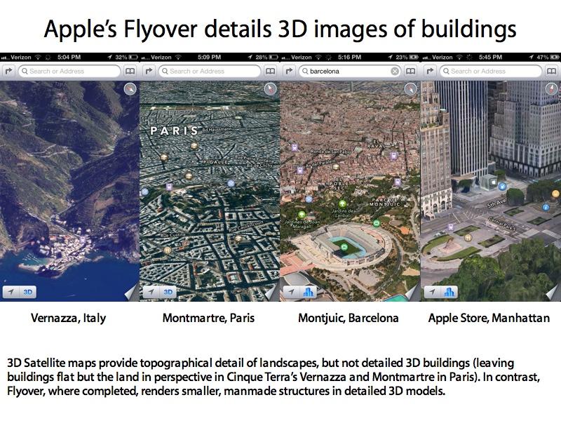
While Flyover does a good job of automatically rendering mountain landscapes in perspective, it can't automatically build photorealistic models of cities, bridges and other small-scale man-made structures. Apple has to manually build models of cities, and this currently limited primarily to US cities (although support for Flyover is quickly spreading).
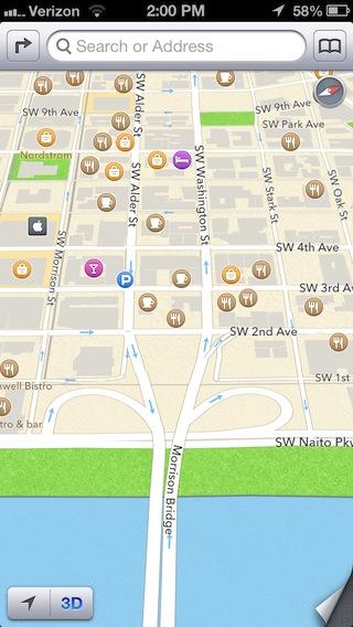
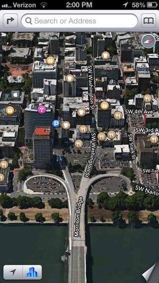
Apple's Flyover works in places its "3D Buildings in Navigation" does not, such as Portland, Oregon, which currently lacks grey 3D models in Standard view, but does have hand-drafted, photorealistic buildings in Flyover (below).
Flyover vs Google Earth, Nokia Maps 3D
Google Earth and Nokia's Maps 3D provide similar views to Apple's Flyover, but only Earth is available on iOS. Nokia offers its beta Maps 3D in 25 cities, but the feature is limited to desktop browsers because it requires a special plugin to work. Nokia also has a slower, plugin-free version but it isn't supported on iOS either; both work from the desktop version of Safari.
While based on the same underlying technology as Flyover, Nokia's Maps 3D are neither as fast and efficient nor as easy to navigate as Apple's multitouch Flyover. Even in the few cities where it has modeled buildings, Nokia's Maps 3D representations are a lot less detailed.

Google Earth offers significantly lower quality renderings and appears to be based on more outdated satellite images compared to Apple's Flyover. Google only supports 3D buildings in a few cities. The product was originally intended to be a cool way to visualize the planet from pieced together aerial photographs, rather than being a functional tool for navigating around, so it can be difficult to zoom in for street level views.
While Apple's Flyover images were a particular subject of complaint for Apple's new iOS 6 Maps, neither Nokia nor Google offer photorealistic 3D city models integrated their mobile maps products for Android or Windows Mobile, and both suffer from significant visual glitches, even in areas where they are supposed to be complete.
Partial satellite perspective views
In its own Android app, Google additionally provides, 45 degree aerial views (for looking down at an angle from one of four directions, in addition to looking straight down) and, in perspective view, tilted satellite images (without topography, and without Earth-like models of buildings). This results in flat views similar to what Flyover looks like in cities where it hasn't been finished (below).
Microsoft also provides what it calls "bird's eye" 45 degree images, which simply show aerial images at four fix perspectives. This results in a series of canned views that can be cycled through to see a particular building from different angles. Apple's Flyover shows depictions from virtually any angle, with smooth animated transitions all the way around.
When comparing Apple's new Maps overall experience to iOS 5 Maps on a technical level, there's no contest: the new Maps app is technically superior, smarter, clearer, looks better and provides several specialized views that are easy to navigate. However, Apple's map service doesn't yet depict detailed maps in some areas. Fortunately, there a variety of apps and websites can be used when you're somewhere that Apple's maps don't provide adequate coverage.
Apple's bold entry into mobile maps
It shouldn't seem surprising that one of Apple's strongest competitive features in iOS 6 Maps is its user interface and visual appearance. However, Apple's main marketing focus with the new Maps hasn't focused on surface appearance as much as its underlying technology, including vector maps and 3D imaging features.
Apple's initial map acquisitions didn't begin until 2009, five years after Google began buying up mapping companies and nearly two years after Nokia spent $8.1 billion to buy Navteq. In addition to assembling a mapping technology group, Apple has shaken up the global mapping industry by throwing its weight behind the primary rival of Google and Nokia: Tele Atlas.
For its global map data, Apple partnered with auto navigation maker TomTom, which acquired Tele Atlas in 2008. Google had been under contract with Tele Atlas, but took its maps product solo just prior to releasing Maps Navigation for Android in 2009 (a primary competitor to GPS devices like TomTom's). Since then, Microsoft's Bing and AOL's MapQuest both moved to Nokia's Navteq maps, leaving Apple the choice between aligning with Nokia as well, or using TomTom's Tele Atlas maps.
If Apple were merely interested in spiting Google, it would appear to have made more sense to just partner with Nokia, which already had a competitive mobile maps product and lots of existing licensing agreements with the primary auto navigation vendors. This would have been far less expensive and would have involved much less effort for Apple both now and in the future to maintain global map accuracy and deal with changes.
Apple's decision to align itself with Tele Atlas (and its acquisition of Nokia's 3D partner C3) indicates that it has a long term intent to compete against both Google and Nokia. Apple's new Maps are a primary feature of iOS 6, not a briefly mentioned feature of iTunes like Ping was.
Apple's in it to win it
Apple's competitive intent is important because it demonstrates that Apple's Maps aren't just a temporary experiment but rather a large scale new initiative. Google has a very strong position in web search with its ad supported maps, but Nokia is actually selling its maps in the automotive space. That's an area Apple clearly wants to enter, and which it has already lined up a series of deals linked to Siri under its new "Eyes Free" initiative for integrating iOS devices to cars.
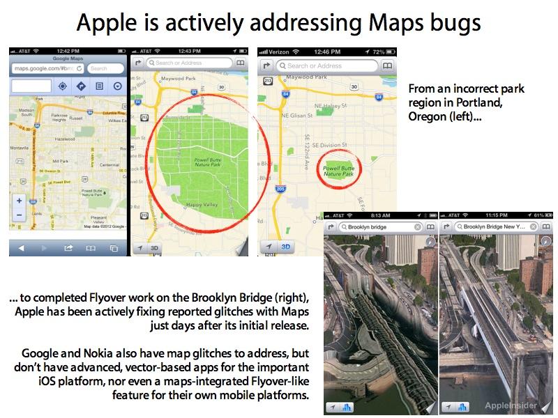
Apple's Maps are clearly a strategic direction for the company. Once the initial complaints about location errors and label typos get resolved (issues that are getting addressed less than three weeks after the new Maps' initial launch), Google and Nokia will have to compete with Apple in pure technology, starting with graphical presentation and visualizations.
That's an area Apple where has significant expertise. A decade ago, Apple brought video game technologies to desktop computing with Mac OS X's innovative Quartz graphics composition engine, beating Microsoft at its own game by six years. It then brought the same advanced imaging technology to the iPhone, something Google was unable to match in Android for three years, and which still hasn't rolled out to more than a quarter of Android's installed base of users.
Apple is now doing the same thing for Maps: taking existing geographical data and presenting it via hardware accelerated OpenGL views optimized for mobile devices. Google and Nokia have their own competing versions of vector based mobile maps, but Google's is currently limited to Android, while Nokia's is now nearly dead in the water following the failure of Windows Phone to gain significant traction over the past year.
Neither Google nor Nokia can bring its vector maps to iOS via the mobile web, simply due to the disadvantages of the web platform. That means both companies will need to deliver native apps for iOS in order to even have a showing on the world's largest and most valuable mobile platform, something neither of which has even targeted with an official release date yet.
Instead, both Google and Nokia have launched a scoff campaign ridiculing Apple's Maps. That strategy didn't work for Palm and RIM when they laughed at the original iPhone's keyboard-free design, didn't work for Microsoft's Windows Mobile, didn't work for Nokia's Symbian or Palm's webOS, and didn't work for Verizon's Droid campaign to sell 4G Android models. It also didn't work well for Apple against Microsoft Windows in the early 90s.
While scoffing at Apple, neither Google nor Nokia have delivered comparable technology that depicts both roadmaps and aerial photos in full perspective with photorealistic models. The tech media has adopted a negative narrative that ignores Apple's technological advances with Maps to focus on temporary glitches, but it's a lot easier to fix bugs than to build all new technology and, importantly, roll it out to paying customers, a significant problem Google and Nokia both face.
Apart from presentation, which has always been one of Apple's stronger points, there are other equally (or if you're stranded, far more) important factors to test out Apple's new map service. The next one up is transit instructions.
5: Routing & traffic

-m.jpg)


 Wesley Hilliard
 Andrew O'Hara
 Malcolm Owen
 Marko Zivkovic

 Chip Loder
 Christine McKee
 William Gallagher


-m.jpg)


84 Comments
Poor Claris hasn't had this much of a workout since her namesake software got replaced with AppleWorks…
Apple is just starting into the Map business. I bet when they update maps (just like they did with SIRI) it will be a major plus. I would use it now as it is. I have to take a 250 mile trip soon and will use iOS 6 Maps.
I think this is one of the longest posts done by Apple Insider.
Apple map uses better technology for displaying and creating the maps.
IOS 6 Maps is already superior but wait 'til new layers of information start coming out from 3rd parties.
When it comes to mapping all the others are toast and they know it.
Time will tell.
Hoover Dam is still screwed in Satellite view. Scalextric FTW!
The only features I previously used in iOS maps were aerial imagery and transit scheduling. For any desktop needs there are numerous options. I applaud Apple for cutting ties with Google since they are not a good partner. If you want specialized features for your maps there are several options available to you through the app store or in a web apps.