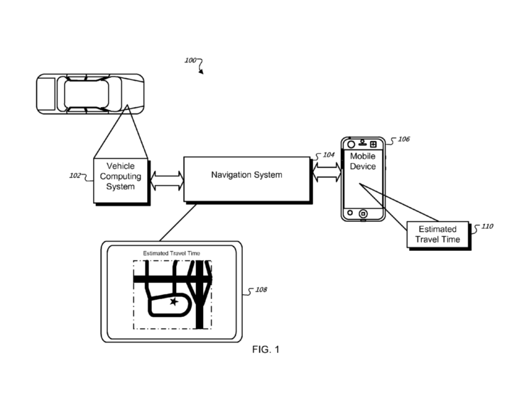
In the recently revealed U.S. patent filing, Apple describes a system for obtaining drivers' personal travel data and using it to estimate driving times. Such a system could take into account speed, time of day, location, driving patterns, season, route type and features, traffic information, road conditions and location data.
Originally filed for in 2008, the patent could save drive times and other data on the local system, and also upload it to a centralized database where the data would be shared with others.
"These features provide customized travel time estimates that take into account a user's driving habits, the characteristics of the vehicle being navigated, road conditions, seasonal conditions, traffic congestion and other factors," the patent application reads, "which cannot be accounted for by conventional statistical calculations based on data samples obtained from a test vehicle or device traveling the route."
The described system would take into consideration a plethora of factors, like stoplights and railroad crossings, and store the data on a server, time-stamped and indexed for easy access.
"The average speeds and/or average travel times for a particular route segment can be collected over a period of time," the document reads, "to provide a historical view of how the average speeds and/or travel times change for different seasons, days of the week, times of day, etc."
Since the iPhone 3G added GPS capabilities, the iPhone platform has become a viable option for those looking for map assistance. Some developers, such as AT&T and Navigon, have developed their own software to take advantage of the phone's hardware.
In June, AT&T released its GPS software solution. Developed by TeleNav and branded as AT&T Navigator, the free application requires a $9.95 monthly service subscription.
Also in June, Navigon released its own MobileNavigator for European residents. The software fetches £54.99 and includes built-in 2D and 3D maps of Europe, allowing it to function without a wireless connection.
Both are bound to face off against an upcoming offering from GPS device maker TomTom, the software for which is being developed with the help of Apple engineers. It will be sold alongside a TomTom car kit accessory, which enhances the iPhone's GPS signal through its dock connector thanks to third-party accessory support built into the iPhone SDK 3.0.
It is unclear whether a potential Apple GPS system would work in tandem with or compete against any of those systems.
 Neil Hughes







-m.jpg)






 Marko Zivkovic
 Mike Wuerthele
 Christine McKee
 Amber Neely
 Sponsored Content

 Wesley Hilliard


 William Gallagher






30 Comments
Waze.co.il has already been doing this for a while, I wonder how they can apply for a patent when there's prior art?
The way this works in Waze is that while the app is running, location data is sent to a central server, which calculates speed. It can even tell when a specific route is congested, just by the sheer number of vehicles driving very slowly. It takes this into account while it calculates an alternative route. I've been enjoying this for almost a year now! :-)
Not to mention Tomtom's Live Traffic and Dash Navigation's Driver Network (now owned by RIM).
I wish in-car GPS had not only a "fastest" and "shortest" button but also a "safest". After a week in a major metro area using one, it often produced a route that no local would choose to take given an alternate, literally going through the worst crime-ridden parts of a city. I know what parts of familiar cities to avoid - we all do. Shouldn't the GPS know the same? This is a lawsuit (maybe not a very good one) waiting to happen - when someone gets car-jacked on a route determined by Garmin or TomTom or Apple.
Things that appear to be similar can be very different in implementation. It's not the outward functions that always matter, but how they are done.You know the expression "There are ten ways to skin a cat."?
Well, they are all patentable.
I wish in-car GPS had not only a "fastest" and "shortest" button but also a "safest". After a week in a major metro area using one, it often produced a route that no local would choose to take given an alternate, literally going through the worst crime-ridden parts of a city. I know what parts of familiar cities to avoid - we all do. Shouldn't the GPS know the same? This is a lawsuit (maybe not a very good one) waiting to happen - when someone gets car-jacked on a route determined by Garmin or TomTom or Apple.
I would doubt that's easily done. There would have to be millions of bits of information for that.
And then communities would sue over being called dangerous. Sometimes this is in the eye of the beholder. Who decides what is dangerous? What standards are applied? Who makes up those standards? How were those people selected? How often do they update the data and conclusions? What about the many errors that will be made? Who is liable for it? Who pays for all of that?