Apple wants the iPhone to be able to lead injured or stranded people to where they can get help, even where lack of internet means traditional location-finding is impossible.
Apple has previously applied for a patent that would mean iPhones could act as emergency beacons, even when away from Wi-Fi or cellular service. Now many of the same inventors are working on ways an iPhone could guide people to where such a system would work better.
"Location selection for transmitting emergency beacons," is a newly-revealed patent application that is concerned with orientating and directing a user.
"Because of their utility, mobile devices, such as smartphones, are standard equipment for hikers, backpackers, mountain climbers, skiers and other outdoor enthusiasts," says the patent application. "Some mobile devices are also enabled with D2D [device-to-device] communication capability, which allows direct wireless communication between two mobile users without assistance from a base station or core network."
"In the case of a natural disaster (e.g., hurricane, earthquake), conventional cellular communication networks may not work," it continues. "In such disaster scenarios, a wireless ad hoc network can be established between two or more D2D devices to obtain emergency assistance."
Apple's previous patent application about emergency beacons is specifically about how two devices can be made to communicate directly, without cell or Wi-Fi connection. This one describes what may happen if there simply aren't two devices in close proximity.
"If a user (e.g., a hiker), however, is alone in an emergency situation in a remote area (e.g., a forest) where no cellular or WiFi service is available," it continues, "the user may not know in which direction to walk to increase their odds of establishing D2D communication with other D2D-enabled devices to obtain emergency assistance."
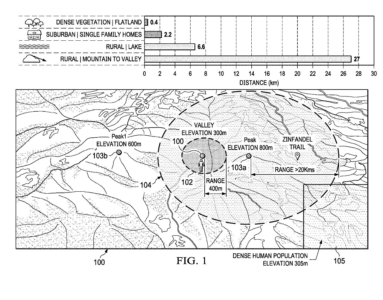 Detail from the patent showing one way in which the iPhone can calculate a likely best direction for a stranded user to go for help
When that is the case, the job is to get the user to a place where there are more people and more devices. It's to calculate which direction is best to send them.
"[That involves determining the] current location of the mobile device in a geographic area," says Apple, "configuring a transmitter of the mobile device for device-to-device (D2D) communication; [and] determining... one or more candidate transmit locations for D2D communication."
Apple proposes that the calculation to determine a "candidate transmit location" be based on a great many factors. That includes elevation, "proximity to a D2D device density location," plus the "availability of a trail or path to the candidate transmit location."
Once the user has selected "a particular candidate transmit location" from those offered, the iPhone has to determine "a route from the current location."
Apple describes this as using "a location processor of a mobile device," but it's also got to work from data about the surrounding area. If Apple Maps could retrieve data about the local surrounding, the user would be able to get help right there and then.
So it has to include the caching of map data, or the pre-loading of information about the area. Either way, Apple says this provides "hikers and other outdoor enthusiasts with a means to obtain emergency assistance using their D2D-enabled device when confronted with an emergency situation in a geographic area with no cellular or WiFi service."
Stay on top of all Apple news right from your HomePod. Say, "Hey, Siri, play AppleInsider," and you'll get latest AppleInsider Podcast. Or ask your HomePod mini for "AppleInsider Daily" instead and you'll hear a fast update direct from our news team. And, if you're interested in Apple-centric home automation, say "Hey, Siri, play HomeKit Insider," and you'll be listening to our newest specialized podcast in moments.
 William Gallagher





-m.jpg)


 Christine McKee

 Malcolm Owen
 Charles Martin



 Mike Wuerthele


-m.jpg)




5 Comments
This is an app which deals with life and death. If the app gives bad advice that kills someone, expect a lawsuit.
But I can see great potential in what started with Air tag now, creating one big network of all iPhone users.
Uh, does a device need cellular service in order to utilize GPS?
There’s so little actual info in what was “described” here, I’m not sure it constitutes a coherent descriptor. In order to have some kind of communication without cellular, the idea is to create a distributed peer-to-peer ad hoc network. If there’s no other device nearby for that distributed network, it directs you toward one... how? And if it can direct you to another device, why can’t it direct you elsewhere?
It’s also kinda cheesy that there’s the repeated phrase “D2D device”, when both letter Ds stand for “device” already. It’s not quite “PIN number”, or “NIC card”, but it’s still sort of annoying.