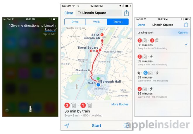
In a change to its Apple Maps Acknowledgements webpage, Apple revealed an initial list of data providers used to populate the upcoming transit mapping feature in Maps for iOS 9, as well as two new aggregators of business listings.
While Apple's Maps attribution page shows a revision date of Jun. 4, 2015, Apple Maps Marketing believes the transit sources are indeed new.
Apple announced earlier this year that transit directions will initially be available in Baltimore, Berlin, Chicago, London, Mexico City, New York City, Philadelphia, San Francisco, Toronto, and Washington D.C., as well as 30 cities in China. The newly published list of providers gives a closer look at what to expect from transit assets in Canada, Germany, the U.S. and UK, including major cities like Berlin, London, New York, San Francisco and Toronto.
Apple Maps transit data providers:
- Berlin transit data © 2014-2015 VBB Verkehrsverbund Berlin-Brandenburg GmbH.
- Berlin transit data from Ostseeland Verkehr GmbH/Alle Angaben ohne Gewähr.
- Germany transit data from Flixbus, a European intercity bus service provider: https://www.flixbus.com
- London transit data © 2015 ITO World Ltd. All rights reserved. Contains public sector information licensed under the Open Government Licence v2.0.
- MTA and the MTA logo are trademarks of the Metropolitan Transportation Authority and used with permission of the Metropolitan Transportation Authority.
- AirTrain JFK data from 511 NY.
- Westchester County transit data from 511 NY.
- Alameda County transit data © 2015
- San Francisco - Bay Area transit data provided by MTC's 511.org.
- San Francisco Municipal Transportation Agency data reproduced with permission granted by the City and County of San Francisco. The information has been provided by means of a nonexclusive, limited, and revocable license granted by the City and County of San Francisco.
- Brampton transit data © 2015, The City of Brampton (All rights reserved.) Subject to terms at: http://www.brampton.ca/EN/City-Hall/OpenGov/Open-Data-Catalogue/Pages/Terms-of-Use.aspx.
- Burlington transit data from the City of Burlington. Subject to terms at: http://www.burlington.ca/en/services-for-you/resources/Initiative Projects/Open_data/TermsOfUse.pdf.
- Grand River Transit data provided by the Regional Municipality of Waterloo under license.
- Guelph Transit data provided by the City of Guelph under an open government license.
- Hamilton Street Railways public sector data made available under the City of Hamilton's open data license.
- Ontario transit data provided with permission of Metrolinx.
- MiWay transit data from the City of Mississauga. Subject to terms at: http://www5.mississauga.ca/research_catalogue/CityofMississauga_TermsofUse.pdf.
- Contains information licensed under the Open Government Licence - Niagara Region http://www.niagararegion.ca/government/opendata/terms-of-use.aspx.
- Oakville Transit data licensed under the Open Government Licence - Town of Oakville.
- Toronto Transit data licensed under the Open Government Licence - Toronto.
As for business listings, Apple added data gathered by Position Technologies and DAC Group.
Apple is expected to release iOS 9 alongside new iPhone models at a special event in September. Aside from mapping enhancements, the next-gen operating system features a revamped Notification Center and app switcher, low battery mode, dedicated iCloud Drive app, Wi-Fi calling for AT&T, numerous user interface tweaks and much more.
 AppleInsider Staff

-m.jpg)


 Wesley Hilliard
 Andrew O'Hara
 Malcolm Owen
 Marko Zivkovic

 Chip Loder
 Christine McKee
 William Gallagher


-m.jpg)


11 Comments
Can we have the ability to 'avoid highways' like Navigon and many other GPS apps for the iPhone?
Seriously. If you give me this ability, I can delete multi-gigabyte Navigon forever.
Can we have the ability to 'avoid highways' like Navigon and many other GPS apps for the iPhone?
Seriously. If you give me this ability, I can delete multi-gigabyte Navigon forever.
Yes, please. It's literally the only reason I ever occasionally launch Navigon anymore, since I no longer seem to drive away from cell coverage. (More often, I still don't use Navigon, I just refuse to get on the high way and let Siri throw a tantrum for 10 minutes before accepting that I'm going my own way...)
This is an advantage of Google Maps that I forget about. If I didn't have Navigon, I'd occasionally use Google for this reason. (Currently, I use it for transit only, and even then I do my search in Apple Maps and let Apple hand the results off to Google Maps.)
I thought it was announced that it was 300 cities in China.
I would love this functionality, but I'd like it taken to the next level. I want a mapping app that avoids freeways, highways, and major city streets. When it comes to horrible traffic, a gps is still going to default to major streets. I'd love to have an app that avoids all of that and uses little-used side streets and back roads. You may have to go a little out of your way, but you won't be stuck in traffic. As of right now, I'm not aware of a single company that does this. You can even call the App "Tertiary".
When transit directions comes out, I can finally get rid of Google Maps.