Affiliate Disclosure
If you buy through our links, we may get a commission. Read our ethics policy.

Apple to use drones, indoor navigation data to improve Maps in 2017

Apple is preparing to use drones, indoor mapping, and better car navigation to improve its Maps apps for iOS and macOS, a report said on Thursday.

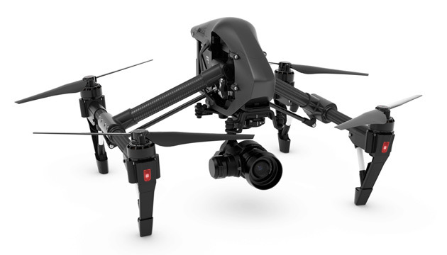
On March 22, Apple secured an exemption from the U.S. Federal Aviation Administration to fly drones from DJI, Aibotix and others for commercial purposes, specifically "data collection, photography, and videography," according to Bloomberg. The company has since committed to official commercial drone guidelines introduced in August.

The drones will be used to capture and update map data faster than Apple's current minivan fleet is capable of, one of several sources said. This includes changes to roads, street signs, and construction.

To boost these efforts, the company is reportedly hiring robotics and data collection experts, including at least one person from Amazon's Prime Air drone delivery project. The new Apple team is said to be gathering in Seattle, where Amazon is based.

The indoor mapping technology, meanwhile, should help people find their way through large-scale public areas like airports and museums. This is why Apple bought startup Indoor.io last year, one source said. Giving the interference buildings can cause, indoor navigation will likely depend on a mix of GPS, Wi-Fi, Bluetooth, and even pressure sensors.

Watch the Latest from AppleInsider TV

In terms of car navigation, the only mentioned upgrade so far includes better guidance when changing lanes.

Both indoor navigation and improved lane assistance are being planned for launch next year, but could theoretically be held back.

21 Comments

Soli 10 Years · 9981 comments

OT: I wonder when their street-level view LiDAR will be released.

4 Likes · 0 Dislikes
volcan 11 Years · 1799 comments

Apple Maps works pretty well in the US but needs a lot of work in many less industrialized countries. I am on vacation in the Caribbean and Maps shows roads that veer off into the ocean and is also missing many streets. Almost zero landmarks or points of interest. One interesting note is that Maps shows a sand bar off shore as actual terra firma. I suppose it could be considered land at an extreme low tide but it probably shouldn't be shown on the map as an island.

3 Likes · 0 Dislikes
monstrosity 18 Years · 2227 comments

Itvolcan

said:
Apple Maps works pretty well in the US but needs a lot of work in many less industrialized countries. I am on vacation in the Caribbean and Maps shows roads that veer off into the ocean and is also missing many streets. Almost zero landmarks or points of interest. One interesting note is that Maps shows a sand bar off shore as actual terra firma. I suppose it could be considered land at an extreme low tide but it probably shouldn't be shown on the map as an island.

It's fairly good in the UK now too. It's now my default map app. Google and Tom Tom don't get a look in any more.

1 Like · 0 Dislikes
blastdoor 16 Years · 3754 comments

This sounds pretty cool. 

I'll score this as something that Jony Ive probably has nothing to do with. 

Soli 10 Years · 9981 comments

blastdoor said:
This sounds pretty cool. 

I'll score this as something that Jony Ive probably has nothing to do with. 

They've had their hands in "indoor mapping" for a long time. WiFiSlam is one such company they acquired years ago.

1 Like · 0 Dislikes