We've gone beyond "the revolution will be televised," and are in a reality where the latest European war is live-streamed not just through social media, but on online mapping services without Google or Apple intending it.
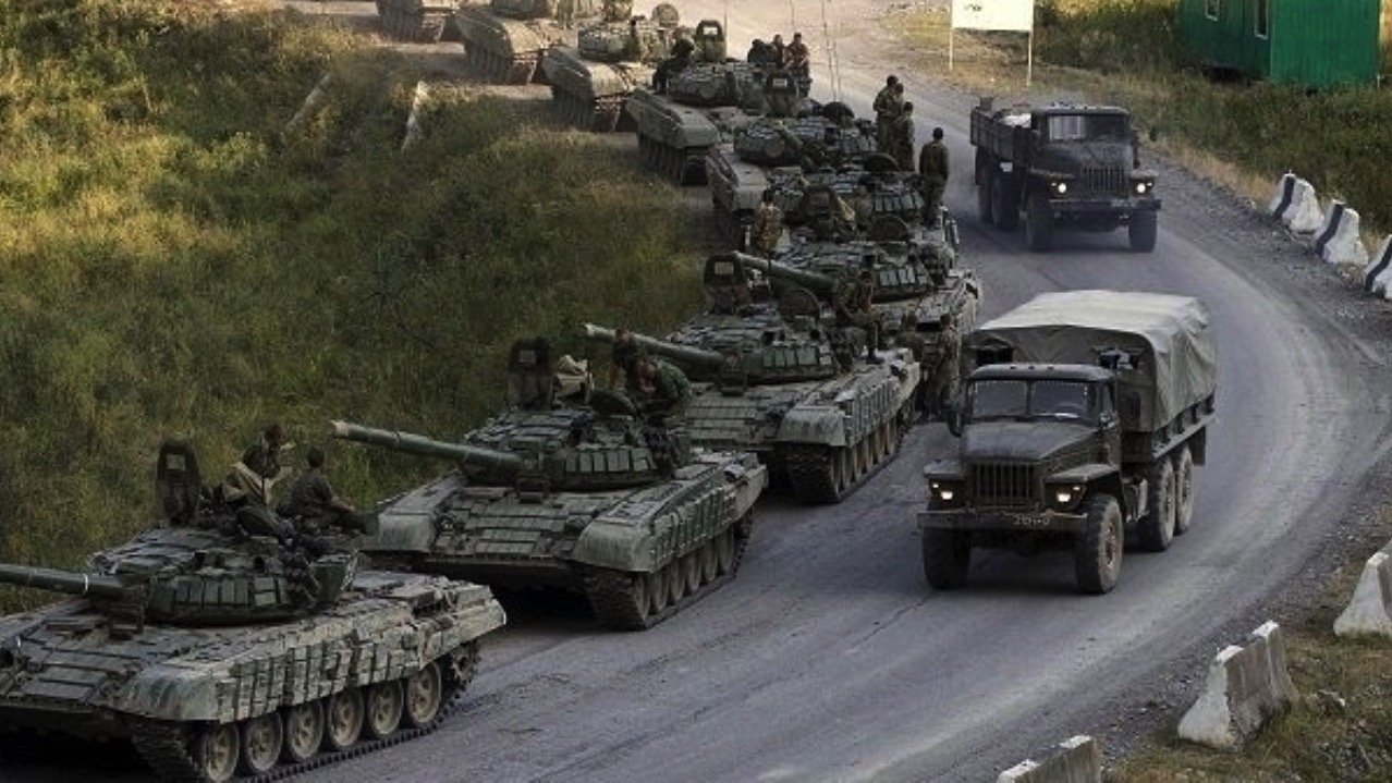
The sheer volume of mapping data now available at our fingertips means it was possible for civilians half a world away to see when Russian forces began moving. Specifically, that data pinpointed a traffic jam starting on the Russian side of the border, actively moving into Ukraine in the first few minutes of the Russian and Ukraine conflict.
Just as with any cartography, this information required interpreting. Google Maps did not specifically say that it was troop movements, nor was its satellite imagery up to the minute. During the process of researching this story, we've confirmed that Apple Maps presented similar inbound troop movement information — but it wasn't setting out to do that either.
What these services did, though, was register all of the smartphone users whose driving was slowed or halted by unusual traffic conditions. Wherever the majority of the data came from, it was possible to determine what was happening when coupled with known details of Russian troop locations.
So it was possible to know that the invasion was starting, long before conventional news could break the story. And, it was all relayed in real-time on Twitter.
That raises issues about the almost accidental power of big tech over issues seemingly far from their intended use. There is now a new clash between civil rights, civilian-oriented technology, and security.
Nobody set out to make Google Maps be a military tool, but if it and other big tech services have become that, they have done so without any kind of oversight. Democracy needs information, but governments want to control it, so you can bet that Google and Apple going to be getting some phone calls about it.
According @googlemaps, there is a "traffic jam" at 3:15 in the morning on the road from Belgorod, Russia to the Ukrainian border. It starts *exactly* where we saw a Russian formation of armor and IFV/APCs show up yesterday.
— Dr. Jeffrey Lewis (@ArmsControlWonk) February 24, 2022
Someone's on the move. pic.twitter.com/BYyc5YZsWL
As for this specific example of the invasion of the Ukraine, tweeter Dr. Lewis told Vice that he thinks he and his team "were the first people to see the invasion."
"And we saw it in a traffic app," he said.
There was more to the work than loading Google Maps and checking out a region President Putin mentioned. Dr. Lewis's team had reportedly also been working from optical and radar satellite imagery from a few days before the invasion.
That imagery made it clear just how extensive the Russian troop deployment was, and where it was positioned.
"We all looked at the picture, and was like, oh shit, it's coming," said Dr. Lewis.
Then they saw the traffic jams on the Russian side of the border that Google Maps was beginning to report.
"So it's the prior work of knowing that there's a giant Russian armored unit sitting right there that allowed us to say, like, oh, I know what that traffic jam is, they're getting on the road," he added.
Just as Apple Maps uses data from iPhones, so Google Maps uses position and motion data from Android. Over time, an unprecedented amount of detail has been gathered by these companies, and is processed in real-time for things like traffic accurate by direction, and not just a blob on a road indicating that one side or the other of the multi-lane highway is blocked.
"We have developed incredibly data rich definitions of what normal patterns of life look like," Dr. Lewis continued. "And any deviation is immediately caught."
Hand in hand with how useful this data has been to researchers like Dr. Lewis is the issue that the same data is available to everyone. And that it has all come about as an intended consequence of big technology.
"I mean, it's cool when we do it, right?" said Dr. Lewis. "It's maybe less cool if the Russians were able to do something similar to, you know, spotting an offensive from Ukranians."
"I think big data companies often don't want to face squarely how useful their data can be," he added.
Big Tech rewrites war
War is about striking either first, hardest, or most decisively. Key to all of this is enemy not knowing where you are.
As a general rule, and incredibly simplifying the matter so as to not put 10,000 words about detection technologies on AppleInsider, sensors on a platform are passive or active. Passive sensors collect emissions made by other units, and active ones like radar use some kind of emission bouncing off a target that are emitted from the sensor.
There are entire groups of people in armed forces focused on emission control. Thousands of man-hours are spent per month on units to keep these emissions down to a bare minimum. In the case of submarines, for example, emissions are kept down by assorted sound silencing efforts, and best practices by the crew inside the vessel to not give away the location of the boat.
And, all that work can be betrayed on that submarine in an instant by a dropped wrench. It wasn't betrayed by Russian troops playing Candy Crush or posting to Twitter in the back of an APC, but operational security was broken by them just having a smartphone on in a pocket of their uniforms.
That data wasn't precise enough to pick out an individual unit, and for civilian purposes it certainly didn't say that soldier serial number whatever is right here, next to this blade of grass. But the movement of the column inbound from Russian territory onto Ukrainian roads was spotted half a globe away, across the internet.
That said, it's not all that clear if the Russian forces as a whole cared about broadcasting their position to the much less powerful and lesser-staffed Ukrainian armed forces. This level of care may vary on an individual troop level, as there are man-portable radio trackers, plus reliable reports from the front that there are Russian prisoners of war, captured early in the engagement.

Poster from World War II, discussing information security. This goal is incredibly more difficult with the proliferation of smartphones and the internet
The scope of the data is known. How much value it was to Ukrainian forces isn't clear yet, but we're expecting to hear some stories about it as the days wear on.
Had this been a larger conflict with a more powerful force than Ukraine's on the other side, it would have been trivial for a battery of cruise missile or drone strikes to have been delivered within minutes in an area denial effort, artillery barrages made, or other munitions to be placed on target by rapid response units just based on the cluster presented by Google Maps.
Swords into ploughshares, and back into swords
Armies use technology, and have (mostly) been at the cutting edge since armies were first assembled. Then there are frightening stories of when military technology goes wrong, or is misused.
A technology first used in the military — GPS — is the most famous example. There are recorded incidents where mis-read GPS coordinates meant missile strikes went horribly wrong.
Nobody developed Google Maps and Apple Maps to be military tools, but they use technologies that were once the cutting edge of warfare. Neither Apple nor Google intended their devices to be used as conduits for troop movement information either through wireless, or by videos posted on social media.
A call went out on social media, begging folks to not discuss Ukrainian troop movements on social media. At the same time, this same information about Russian movements were wanted. It's not at all clear what Twitter or other venues will do if this becomes a prolific thing, but it's pretty clear that when the service was formed that this use wasn't considered part of the core functionality.
Powerful devices with location identification and gathering, connected to a mobile internet, with incredible cameras are a fascinating example of technology's impact on warfare and information gathering from the front. Today's armies are still stumbling into this. Tomorrow's forces will be using this accidental feature intentionally.