Apple on Tuesday was awarded a patent for harnessing onboard iOS device sensors to automatically switch from one location subsystem, such as GPS and indoor wireless gateway proximation, to another seamlessly and without user interaction.
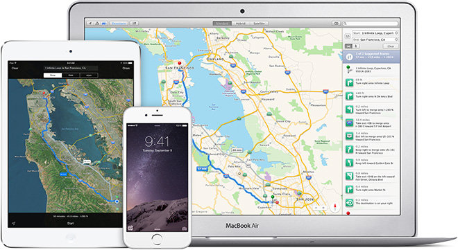
As granted by the U.S. Patent and Trademark Office, Apple's U.S. Patent No. 9,066,207 for "Managing states of location determination" describes a system by which portable devices leverage location, communications and other sensors to gather information that can help determine state of motion and venue. In exemplary embodiments, an iPhone is capable of providing seamless directions from a car, outdoors or in buildings.
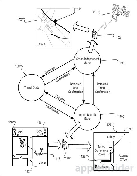
In practice, a user device determines its current state using a first sensor subsystem. For example, an iPhone gathers location information outdoors through reception of GPS satellite signals. Apple refers to unobstructed outdoor states as venue-independent. As with the current Maps app, mapping servers provide navigation and real-time location information.
Moving into a building or other areas in which GPS is unavailable defers device operation to a venue-specific state. In lieu of GPS, structures might contain wireless access points whose RF signals might be stored in a fingerprint location database. Alternatively, a change in state may be determined when an iPhone senses barometric pressure fluctuations denoting changes in elevation between floors of a building. Data from onboard gyroscope, hygrometer, microphone, accelerometer or light sensors also inform the process.
Importantly, the transition procedure expects a second subsystem to be capable of rendering a more accurate location estimation than the first. Transitioning between a weakening GPS signal to a stronger indoor RF signal, for example, is sufficient to perform a handoff.
Switching from a venue-independent state to a venue-specific state, the mobile device pull data for a venue map like an indoor map. In such situations, specialized venue maps are provided for pathing through hallways, rooms, walls, offices and other identifiable features.
While not mentioned by name, Apple's iBeacon microlocation technology would seamlessly into today's patent. Bluetooth-enabled iBeacons could theoretically replace wireless access points in Apple's document, providing accurate location data while providing an interactive indoor mapping experience.
Apple has yet to roll out consumer facing technology acquired through its purchase of indoor mapping startup WiFiSLAM in 2013. Today's patent, however, is an indication the company still plans to expand services beyond street maps.
Apple's patent for a self-determining, venue-based location system was first filed for in December 2012 and credits Lukas M. Marti, Robert Mayor, Shannon M. Ma.
 Mikey Campbell


-m.jpg)

 Charles Martin
 Christine McKee
 Wesley Hilliard
 Malcolm Owen
 Andrew Orr
 William Gallagher
 Sponsored Content





11 Comments
Google is far ahead of them! With Google Nest thermostats acting as remote data points and Google Nest "security" cameras performing the visual mapping, you'll be able to get a guided tour of your house complete with first-person views of it all. Buy Google Nest products and you'll be able to navigate your house more easily than ever. Google Android will be the first indoor mapping solution than can guide you from the back window to the teenage daughter's panty drawer.
[quote name="Roake" url="/t/186872/apple-mapping-patent-provides-seamless-outdoor-indoor-location-determination#post_2738873"]Google is far ahead of them! With Google Nest thermostats acting as remote data points and Google Nest "security" cameras performing the visual mapping, you'll be able to get a guided tour of your house complete with first-person views of it all. Buy Google Nest products and you'll be able to navigate your house more easily than ever. Google Android will be the first indoor mapping solution than can guide you from the back window to the teenage daughter's panty drawer.[/quote] Sounds sinister.
Google is far ahead of them! With Google Nest thermostats acting as remote data points and Google Nest "security" cameras performing the visual mapping, you'll be able to get a guided tour of your house complete with first-person views of it all. Buy Google Nest products and you'll be able to navigate your house more easily than ever. Google Android will be the first indoor mapping solution than can guide you from the back window to the teenage daughter's panty drawer.
What you wrote is pure Bullshit...
Apple Maps is actually better than Google Maps because Apple presents its maps and navigation with a better UI , it is therefore more usable.
With superior FlyOver and seamless street level view integration, better transit navigation, seamless indoor / outdoor integration coming to Apple Maps, Google Maps is toast and they know it. It does not matter how much data and of what quality the data that Google has collected because if they can't present it properly in a usable manner, it is useless.
Google made a big mistake by withholding maps data from Apple and they will live to regret it.
Update:
Ohhhh wow, LOL. I did miss the "satirical nature" of your post. It was too early in the morning here...
Spot those who missed the satirical nature of the post they're responding to.
I support Apple Maps and use it frequently, but there's room for improvement. In NYC this weekend, I was in Central Park and asked my Apple Watch, "How do I get to Lincoln Center?" (It's a 10-minute walk from where I was.) It began well, finding a destination, displaying it on my Watch, and allowing me to hit the "Start" button. But... when I began walking, the instructions kept saying "Proceed to Central Park West" -- that is, the Watch (or iPhone) were never able to confirm that my location was ON the route and ready to move to the next step. Is this due to tall buildings blocking GPS reception & positioning? That was what I was testing, actually.