 Mikey Campbell
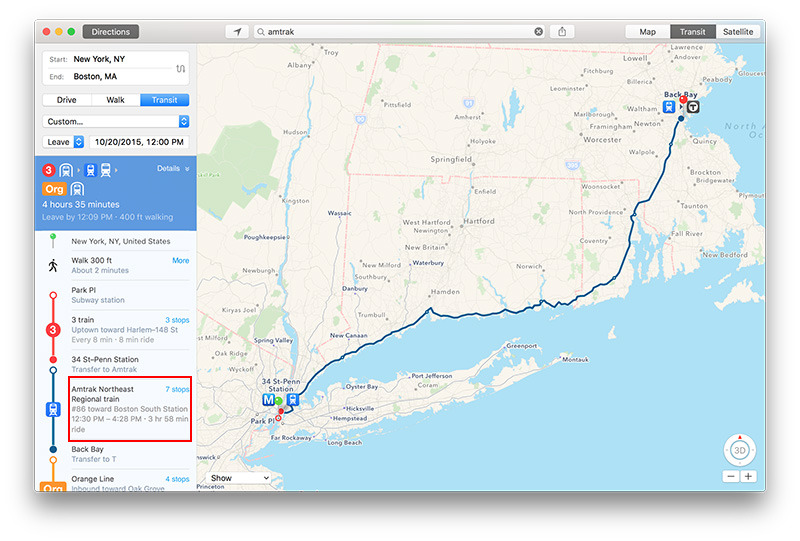
One month after Apple debuted transit directions in its Apple Maps service, the company on Monday added train arrival and departure data for select Amtrak routes, as well as local support for Boston.
With the new data integration, spotted by MacRumors, users now have access to information covering Amtrak's Northeast Regional, Acela Express, Keystone, Lake Shore Limited, Pennsylvanian and Maple Leaf lines. Data is largely limited to certain cities where transit directions are already available in Apple Maps.
In addition to Amtrak timetables and routes, Apple Maps' transit functionality went live in Boston with full infrastructure support for bus, subway, trolley and rail services, The Boston Globe reports. Apple announced plans to bring transit directions to the Boston area earlier this month.
Apple Maps transit compatibility is slowly rolling out in major cities around the world. Currently, the service is available in Baltimore, Berlin, Chicago, London, Mexico City, New York City, Philadelphia, San Francisco, Toronto and Washington D.C., as well as 30 cities in China.
For Apple Maps, public transit integration has been a long time coming. Competitor Google Maps has for years offered similar features, but Apple's service adds in extra functionality like top-down views of underground subway and train stations for efficient route planning. Apple Maps also incorporates Siri virtual assistant commands and digital reproductions of real life signage, allowing users to more easily recognize upcoming stops.


 Charles Martin

 Malcolm Owen
 William Gallagher

 Christine McKee
 Wesley Hilliard


9 Comments
I live on a street created about 2 years ago. I notified Google about it and they had it in their maps about a week later, along with a Thank-You email. I've notified Apple 3 times now, and nothing. Even gave them the info on how to contact my county's GIS department. Silence. So what good is their feedback in the Maps app if they just don't do anything about it when you report a problem? Sorry for the rant .... but the article subject WAS Maps.
I mapped a route from work in Lancaster, PA to home in Harrisburg, PA yesterday. The route was a combination of walk, ride Amtrak then walk. Not bad. I forgot to check train delay reporting yesterday. Looking forward to testing this capability today. Keep up the great work, Apple!
Transit directions are spot on in Boston. This is the first Transit routing app that gets my commute correct. My commute is funky because I live near an outbound only bus stop... so in the morning I actually catch an OUTBOUND bus... and ride it around until it becomes an inbound bus and makes its way to the nearest subway station. Every other transit app has me start my commute by walking a mile or so to catch the same bus at an inbound stop. It would technically work... but it's not ideal. Apple Maps nails it exactly right. Another cool side effect of Transit directions coming to Apple Maps is that any apps that depend on that capability now just came alive in Boston. One of those is ETA. I bought it because it looked cool... only to find out that it relies on Apple Ttansit directions... but just yesterday it started working in Boston!
[quote name="Wings" url="/t/189622/apple-maps-integrates-select-amtrak-routes-boston-area-transit-directions#post_2793138"]I live on a street created about 2 years ago. I notified Google about it and they had it in their maps about a week later, along with a Thank-You email. I've notified Apple 3 times now, and nothing. Even gave them the info on how to contact my county's GIS department. Silence. So what good is their feedback in the Maps app if they just don't do anything about it when you report a problem? Sorry for the rant .... but the article subject WAS Maps.[/quote] Have you tried the support page on the web instead?
Wings, meanwhile, I had the exact opposite experience, they made a road I lived on into a dead end (used to be a through streets but people were flying down it to get around 2 lights). Submitted fix to Google and Apple Maps. Apple Maps fixed it and pushed a thank you it's fixed to my device about a week later. Google changed into into a one way, submitted another fix, they changed it into a one way that was a dead end (w.hat?!?@), submitted another fix, they got it right finally (or so I thought). About 2 weeks later friends came to visit and they call "we're outside your house", look outside...no one there, "do you happen to remember the exit you took?". Turns out they were several towns over on the same street name in that town. Apparently the last change Google decided to change the name of our street and put a space in the middle. So when they put in our address, it redirected them to the nearest version of that street name not the one closest matching it in the town they entered. Explain they have about a 45 minute more to drive, after already 4 hours on the road. So, submitted another fix, they get rid of the space and change it from Rd to St (it's Rd and always has been). Submit yet another fix, finally several fixes later it's right. I guess the moral of the story is *puts on sunglasses* your mileage may vary! (sorry couldn't help myself) [EDIT] Fixed a few misspellings I noticed.