Joined by a new dedicated indoor mapping app, Apple has also begun encouraging large venue owners to sign up for its "Maps Indoor" service, potentially laying the groundwork for advanced indoor step-by-step directions in future iPhone updates.
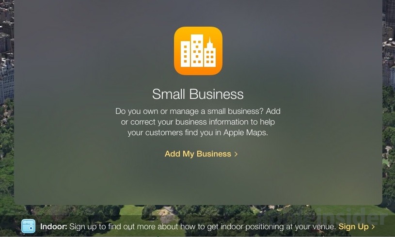
Maps Connect members signing into the website are greeted with a banner at the bottom of the screen promoting the Indoor initiative, including the same icon as Apple's hidden "Indoor Survey App." The promotion for Maps Indoor was first spotted by AppleInsider reader Branch.
For now, Maps Indoor venues must be open to the public and attract more than a million visitors per year.
While Apple is pushing its indoor mapping initiative, the program remains limited to large, public venues. Prior to signing up, Apple warns venue owners that the company has "received an overwhelming response on this service."
For now, Apple is focusing its efforts on a handful of venues that meet specific criteria. These requirements include:
- The venue must be accessible to the general public
- Only locations that draw more than a million visitors per year
- Apple requires "complete, accurate, and scaled reference maps" for consideration
- The venue must have Wi-Fi throughout, and an official app available on the App Store
In the short term, Apple's indoor positioning efforts help its proximity-based iBeacons, allowing developers to build interactive features that respond based on a user's location. For example, a shopper in a store might get alerts about special deals in a specific department as they walk through it.
In the longer term, Apple's indoor mapping program will help the company offer indoor navigation and positioning. This could be used to give iPhone owners detailed step-by-step directions inside places where GPS is not available, such as in a shopping center or an underground subway station.
While the Maps Indoor initiative has been around since iOS 8, Apple expanded it with public transit in Maps with this year's iOS 9 update. Specifically, iOS Maps include subway station underground layouts, complete with specific entry points, when using transit.
And while iOS Maps do not yet offer pinpointed locations while indoors, the inclusion of the mapping data itself lays the groundwork for future technology.
Apple acquired "indoor GPS" company WiFiSLAM for $20 million in 2013. The company has also filed numerous indoor navigation-related patents.
 AppleInsider Staff






-m.jpg)



 Charles Martin
 Christine McKee
 Wesley Hilliard
 Malcolm Owen

 Andrew Orr
 William Gallagher
 Sponsored Content







8 Comments
I may live to eat my words... but I believe this is the beginning of something big -- that will have a pervasive impact on how we use our phones in the future. Navigating in stores, sports arenas, hospitals, etc.
It should be noted that Google has offered to map and photograph businesses of almost any size for years for their street view. I've actually "walked inside" a number of locales on Google Maps just for fun. Apple should contract out to freelancers to perform this same function to build out Apple Maps faster.
This is going to be something great. I like the concept of home use...if my house system knows where I am at and can trigger certain events based on this...if I am sitting on the couch in the living room for example...the system acts differently...siri may be more geared to tv/movie/music functions or in my case lighting and fan operation as well...if I am in my bedroom...tv/bed/light focus...could also build in assumptions...true definition of smart home. The public thing could be awesome as well...just something simple as finding my wife in Target. Would be made so easy. The whole Disney experience could be made pretty cool with augmented reality and such. Cool stuff.
I may live to eat my words... but I believe this is the beginning of something big -- that will have a pervasive impact on how we use our phones in the future. Navigating in stores, sports arenas, hospitals, etc.
I could see this for museums, shopping malls, sports arenas and the like, but I wonder if hospitals, government offices and even colleges would consider such detailed mapping of their facilities to be a security risk.
Also, an old facility like the Museum of Natural History in NYC is a rabbit maze and there are many areas of the museum in which you currently can't get phone service, it would probably be quite expensive for them to place WiFi throughout the facility.
I see it as something useful, but only for large facilities. How many times a year does any individual find themselves in a large facility where they need an electronic map to find something? Even in a stadium, I would't use it to find my seat - the signage is good enough. I might use it to find a particular restaurant. Likewise in a shopping mall, the posted maps are already fine to find a particular store. It could be very useful in large museums, but how many truly large museums are there? In NYC, I could see it being only useful at the Museum of Natural History and the Met. So while it sounds great, I actually think the practical uses are somewhat limited in day-to-day life.
"Also, an old facility like the Museum of Natural History in NYC is a rabbit maze and there are many areas of the museum in which you currently can't get phone service, it would probably be quite expensive for them to place WiFi throughout the facility." Oddly enough that museum ALREADY has a location service which provides an internal navigation service as well as directed tours via their dedicated APP. http://www.amnh.org/apps/explorer