The U.S. Patent and Trademark Office on Tuesday granted Apple a patent for the graphical user interface used in all versions of the iOS Maps app since the software was first introduced in iPhone OS 2.0 and the iPhone 3G in 2008.
Apple's U.S. Patent No. 8,302,033 for a "Touch screen device, method, and graphical user interface for providing maps, directions, and location-based information," which described the backbone UI for the Maps app that continues to be used in the latest iOS 6.
Apple's Maps app debuted with the second generation iPhone OS, which would later be called iOS, and was powered by Google Maps until the most recent iteration of the software ditched the search giant's service for a proprietary solution created in-house.
First filed for one month before the iPhone 3G debuted in July 2008, Apple's patent sought to improve upon the then-current state of GPS systems by leveraging the iPhone's multitouch display, GPS receiver and wireless communications assets.
From the patent's background:
Some portable communication devices (e.g., mobile telephones, sometimes called mobile phones, cell phones, cellular telephones, and the like) have resorted to adding more pushbuttons, increasing the density of push buttons, overloading the functions of pushbuttons, or using complex menu systems to allow a user to access, store and manipulate data.
In addition to ridding the device of unsightly and inflexible buttons, Apple looked to enhance user interaction by inventing a totally new UI that eschewed the "time consuming requirement to memorize multiple key sequences and menu hierarchies" associated with existing solutions.
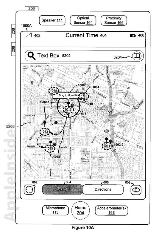
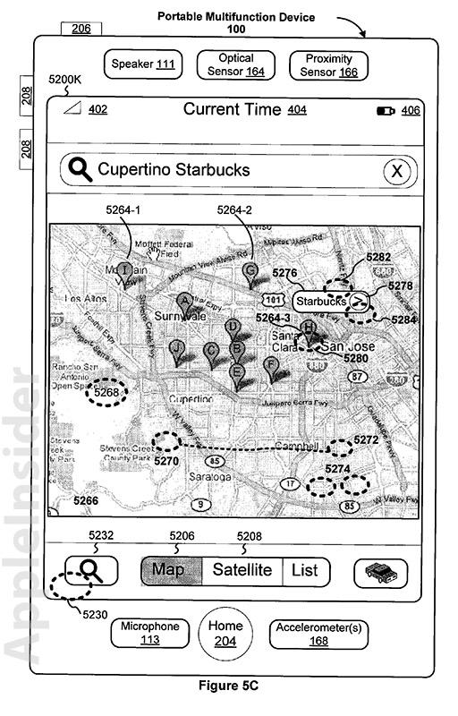
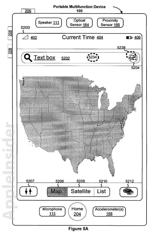
Simply put, the invention replaced physical buttons with an interactive GUI that was able to adapt and change dynamically in response to system or user requests. By sliding a finger across an iPhone's display, a user was able to navigate within the digital map. In contrast, many devices at the time required push buttons to scroll through map sections that were accessed in chunks.
Another function covered by the '033 patent was bookmarking. A user was able to access bookmarked locations, a list of recent searches, or a list of contacts by touching their on-screen representations, which would then display the asset's location on a digital map. In the original Maps, bookmarked locations were accessible by touching a blue book icon in the app's search bar.
Bookmarks worked in the same way as the current iOS Maps app, and can be stored by scrolling through the map data and placing a marker via a touch-and-hold finger gesture, which would result in a "dropped pin" animation. Users simply use the same method to "pick up" the pin, which can be moved to a new location. This same input could also be used to initiate routing operations as well as other functions, such as the now deprecated Google Street View.
Bookmark screen.
Zooming in and out also remains the same as outline by the 2008 patent, with two-finger pinching and other gestures covering how a map is displayed on screen. Also included in the overall aesthetic was the options menu hidden behind the maps screen, which could be accessed by touching the bottom right corner of the display or swiping up from said corner to activate a "roll up" animation. To close the menu, which contained options like a traffic overlay, a user simply swiped down or touched a specific area of the display to initiate a "roll down" animation that brought the map back into view.
In addition to the basic navigation of Maps, the invention called on the iPhone's cellular communications platform to deliver route and mapping information, thus negating the need for on-board storage of an entire map data set. This also allowed for the inclusion of the familiar blue dot and surrounding circle that denotes either the exact location or approximate location of a device, depending on GPS signal strength or cell tower triangulation.
While many of the patent's assets are still used in the most recent iOS Maps version, some have been tweaked as Apple ended its contract with Google Maps to create its own standalone mapping service. Despite being met with criticism for drastically changing the underlying data set, the new app uses many of the GUI assets first outlined in the '033 patent over four years ago.