Apple wants to 'rethink' how people use Maps for iPhone, iPad
 Neil Hughes
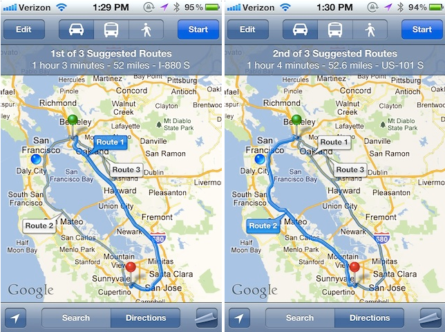
Location services on the iPhone and iPad have been an area of great focus for Apple for some time. That interest continues to grow, as Apple this week posted three new job listings for iOS software developers focused on the native Maps application and discovered by AppleInsider.
"We want to take Maps to the next level and rethink how people use maps, location and geo information," one listing reads. "We want to do this in a seamless, highly interactive and enjoyable way. We've only just started!"
The description is very similar to a job listing posted by Apple in late 2009, which also mentioned taking Maps "to the next level" and an effort to "rethink" the software. But the 2011 version found in the new job postings makes additional mention of location services and geographical data.
The new employees are asked to be familiar with navigation, along with GPS and location-based services. The three job listings only add to the mounting evidence that Apple could be working on its own turn-by-turn navigation service for the iPhone, perhaps similar to the free Google Maps Navigation available on Android devices.
The latest job postings come only days after separate listings by Apple revealed the company is working on "exciting new features" for location-aware software on the iPhone. For that role, Apple also seeks an employee who has experience with "navigation algorithms."
Apple has been on something of a hiring spree related to location services in 2011. In March, the company put a call out for more than two dozen positions related to iOS development, with a particular focus on location services. More job listings from that same month revealed that the company wants to "radically improve" the native Maps application for iPhone.
Apple's forthcoming iOS 5 will add alternate routes to Maps.
News of a forthcoming navigation service was publicly disclosed by Apple in April, when the iPhone maker revealed to the U.S. government that it is working on a "crowd-sourced traffic" service for the iPhone. It was said that the location-based traffic service was planned to become available in "the next couple of years."


 William Gallagher
 Andrew Orr
 Malcolm Owen
 Christine McKee
 Chip Loder


41 Comments
Apple should have "rethought" maps for iOS 5. I guess with this posting we have to wait another year. Is it that hard to build in turn by turn nav with caching so that you can load in the destination and relevant map data and get to your destination?
The maps in iOS 5 are not bad, don't get me wrong. The things maps app does it does extremely well, including transit directions and walking directions. But it is lacking some pretty essential features I described above, and with siri and nuance the maps could be voice requested and voice guided.
We'll see what happens, but I am happy that at least the ball is rolling now.
PS: also can we get a speed indicator in maps somehow?
Apple is once again adding to its iOS Maps software development team, calling for job candidates who will help "rethink" how iPhone users rely on maps, location and geographical information.
Location services on the iPhone and iPad have been an area of great focus for Apple for some time. That interest continues to grow, as Apple this week posted three new job listings for iOS software developers focused on the native Maps application.
"We want to take Maps to the next level and rethink how people use maps, location and geo information," one listing reads. "We want to do this in a seamless, highly interactive and enjoyable way. We've only just started!"
The description is very similar to a job listing posted by Apple in late 2009, which also mentioned taking Maps "to the next level" and an effort to "rethink" the software. But the 2011 version found in the new job postings makes additional mention of location services and geographical data.
The new employees are asked to be familiar with navigation, along with GPS and location-based services. The three job listings only add to the mounting evidence that Apple could be working on its own turn-by-turn navigation service for the iPhone, perhaps similar to the free Google Maps Navigation available on Android devices.
The latest job postings come only days after separate listings by Apple revealed the company is working on "exciting new features" for location-aware software on the iPhone. For that role, Apple also seeks an employee who has experience with "navigation algorithms."
Apple has been on something of a hiring spree related to location services in 2011. In March, the company put a call out for more than two dozen positions related to iOS development, with a particular focus on location services. More job listings from that same month revealed that the company wants to "radically improve" the native Maps application for iPhone.
Apple's forthcoming iOS 5 will add alternate routes to Maps.
News of a forthcoming navigation service was publicly disclosed by Apple in April, when the iPhone maker revealed to the U.S. government that it is working on a "crowd-sourced traffic" service for the iPhone. It was said that the location-based traffic service was planned to become available in "the next couple of years."
Apple has even made key acquisitions to expand mapping software for iOS, with the purchase of Google Maps competitor Placebase in 2009, while another online mapping company, Poly9, was acquired in 2010.
How will it crowd-source traffic? Users give updates while driving? No. Keep GPS on and push data up to the cloud? No, wastes battery. Best option is to continue with what DOT does now, using sensors.
Also, it'd be great to finally have good mapping software on phones. Mapping software in general should be easier to use. For example ArcGIS is the Windows of mapping software but its interface is archaic, ugly, and difficult to use, particularly at first.
Mapping apps on Droid and iOS I would say so far are suboptimal, particularly in the interface. I'd really like it if someone replicated ESRI's ArcPad functionality, only easier to use, and cheap. On iOS and Droid. But still working with shapefiles and with the power of GIS. If anyone can tackle mapping software it'd be Apple. Hopefully they hire GIS programmers and cartogrpahers, to really knock this out of the park.
iOS users will still use Google maps even if Apple creates their own app.
iOS users will still use Google maps even if Apple creates their own app.
You mean backend, or the mapping data. Apple already has its own maps app that happens to load maps from google, but I guess could do the same with just about any mapping provider.
I would have to agree, if apple can't match the google maps quality it should keep the backend. But the app itself should get an update.
iOS users will still use Google maps even if Apple creates their own app.
Remember that Map app on the iPhone is Apple's own App not a Google App, it simply uses Google Maps. I suspect something is coming and I hope it is an all Apple mapping system top to bottom.