Apple introduced a new look in Maps with iOS 10, but more importantly implemented key search and discovery features, as well as backend tools for app extensibility that make navigating everyday life a little more convenient.
The most apparent change in Maps is the design — graphics are brighter and text is bolder, especially convenient for navigating while in the car. Working in cooperation with the revamped aesthetics are powerful functions for point of interest queries, navigation aids and handy features like placing a way finder for a parked car.
Search Bar and Searching Nearby Locations
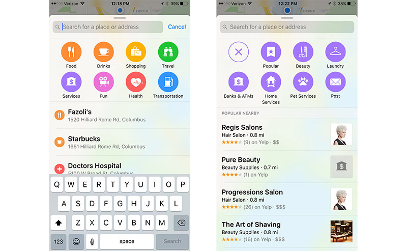
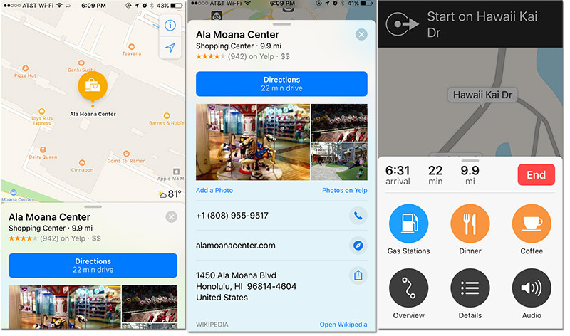
As seen above, Apple incorporates a new search bar located in a swipe-able card at the bottom of the screen. Tapping on the search bar brings up familiar icons that represent nearby attractions. While the update includes the usual options such as Food and Gas Stations, a number of other categories have been added in iOS 10, including Travel, Health and Services.
Subcategories offer further information on nearby POIs, for example Services breaks into Beauty, Laundry, Banks and ATMs, Home Services, Pet Services and Post.
Under the Search Bar and icons are entries for previous searches and suggestions based on calendar appointments, favorite locations, home location and work address.
Adding Quick Stops


With Siri integration, Maps now offers users the ability to estimate how much extra time it will take to get to your final destination if you decide to take a detour. For example, adding a Quick Stop at a gas station or coffee shop automatically calculates additional time to a given route.
With a designation entered and navigation en route, slide the bottom menu up to reveal Gas Stations, Lunch, Coffee, Overview, Details and Audio icons. Click on the detour type to find information on nearby businesses.
Selecting an options and pressing the "Go" button adds the Quick Stop and switches the navigation view to direct toward that location. At the top of the screen is a "Resume Route" option, which can be tapped when a detour stop is completed.
Booking Reservations and Ride-shares


Thanks to third-party app integration, Maps can now be used to book restaurant reservations or hitch a ride with ride-sharing options like Uber and Lyft. Once a desired destination is located, tap on "Directions" to find information on the amount of time it will take to drive, the exact distance, the fastest route option and directions via Drive, Walk, Transit or Ride. Click on Ride for fare and wait time estimates for Uber and Lyft.
If a restaurant accepts OpenTable reservations it will be available next to the button offering you directions to the restaurant. However, you do have to download an app like OpenTable to book via the Maps app.
Finding Your Parked Car
The new Maps app also helps remember where your car is parked. Maps will automatically log an iPhone user's vehicle's location at the end of of a trip that does not end at a user's home address. The information can be quickly recalled as a Destination within Maps.