Google unveils new 3D maps coming to iOS and Android
Last updated
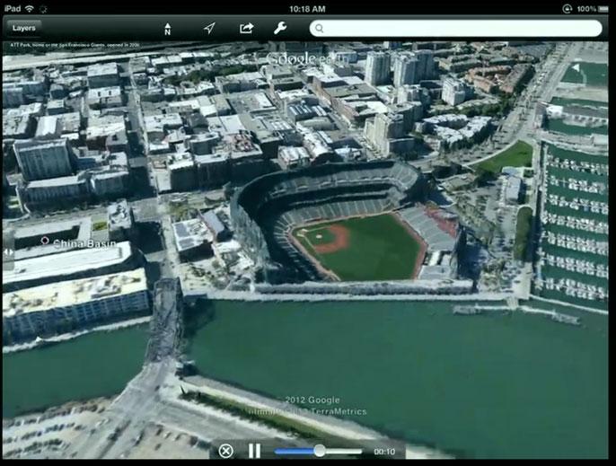
Google has been using automated technology to extract data from aerial models captured by airplanes owned by the company. With planes flying overhead in tightly controlled patterns snapping pictures, Google can use the imagery and data to create three-dimensional mapping imagery.
Images of the ground are snapped from 45 degrees at four angles, and those pictures and data can be combined to recreate maps in three dimensions. The whole process allows 3D maps to be built without human interaction, unlike with previous 3D imagery in Google Earth.
In a live event on Wednesday, Google demonstrated 3D models of individual buildings and entire cities. The new features were shown off to members of the press on an Apple iPad, rather than an Android-based tablet.
The company promised that its new 3D imagery will be coming to both iOS and Android devices "in the coming weeks." The technology will be part of both the Google Maps service, as well as its Google Earth application.
By the end of the year, Google expects to have communities home to about 300 million people mapped in its new space.
Google also revealed that it will bring an offline version of its Maps software to Android devices. The company said it is "working very hard" to bring offline Maps to iOS as well, but did not offer any more information.
Google Maps 3D demo on iPad, via The Verge.
Wednesday's media event comes just five days before Apple is set to hold its own keynote address at the company's annual Worldwide Developers Conference. There, Apple is expected to unveil an all-new version of its Maps software for iOS that will ditch Google Maps.
The Wall Street Journal reported this week that Apple's new mapping technology will reach iOS later this year. It is expected that the all new native Maps application will be a part of iOS 6, Apple's anticipated next-generation mobile operating system.
 AppleInsider Staff


 Amber Neely
 Thomas Sibilly

 William Gallagher
 Malcolm Owen
 Christine McKee


93 Comments
Didn't seem to me like they had much to really "unveal" here. They talked about the past more than they did about "whats coming". Thier app crashed about 4 times too... seems really thrown together.
Also they said the process is totally automated... I doubt the pilots that have to fly over every city on earth with a special camera think so.
Probably because it WAS thrown together to beat Apple out. This could definitely take the wind out of Apple's iOS announcement sails. Seems like one of the biggest if not THE biggest feature of iOS is the 3D mapping.
Neat feature but didn't require a media event IMHO.
Probably because it WAS thrown together to beat Apple out.
This could definitely take the wind out of Apple's iOS announcement sails. Seems like one of the biggest if not THE biggest feature of iOS is the 3D mapping.
If that's the "wow" with iOS 6 I think it will be a bit of a letdown. Especially if their new mapping app doesn't have turn by turn navigation. Google unveiling this now, and on an iPad wasn't by accident.
Probably because it WAS thrown together to beat Apple out.
This could definitely take the wind out of Apple's iOS announcement sails. Seems like one of the biggest if not THE biggest feature of iOS is the 3D mapping.
So a thrown together demo of a feature that's been in beta for about a year and which crashed 4 times is going to take out the wind of what is likely to be an almost finished product (at least the parts demo'd would be) that is also likely to be well thought out? What is reported as being shown at this 'event' certainly makes it seem a very defensive move by Google.