Apple hands off transit directions to third-party apps in iOS 6 Maps
Last updated
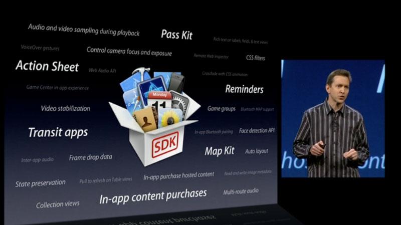
The ability of third-party developers to create transit apps for iOS 6 was highlighted by Apple's iOS software chief Scott Forstall at Monday's Worldwide Developers Conference keynote. He noted that a new application programming interface for transit apps to interface with Maps is a part of iOS 6.
"When building Maps, we looked around and realized the best transit apps for metros, for hiking, for biking, are coming from our developers," Forstall told developers. "And so instead of trying to develop those ourselves, we are going to integrate and feature and promote your apps for transit right within the Maps app in iOS 6."
No further details on exactly how third-party applications will be discovered or promoted within iOS 6 Maps were provided. But release notes accompanying the first developer beta of iOS 6 describe how apps without their own map support have an easier way to launch the Maps application and display directions or points of interest.
"Apps that offer routing information, such as turn-by-turn navigation services, can now register as a routing app and make those services available to the entire system," the release notes explain.
"Registering as a routing app gives you more opportunities to get your app in front of users. Routing apps are not limited to just driving or walking directions. Routing apps can also include apps that provide directions for the user's favorite bicycle or hiking trail, for air routes, and for subway or other public transportation lines."
It goes on to say that Maps "knows about routing apps in the App Store," and will provide users with the option to download those applications for directions even if they are not already installed on that particular device.
The new APIs for routing and transit apps are a change from previous builds of iOS, which feature Google Maps data and services. Google's mapping solution features its own built-in directions for public transportation, biking, hiking and more.
 Neil Hughes






 Amber Neely
 Thomas Sibilly

 AppleInsider Staff

 William Gallagher
 Malcolm Owen

 Christine McKee








77 Comments
The keyword is within the maps app.. It would've sucked it was a separate third party solution outside of the maps app. I think that means the maps app will become a platform.
I'm pretty sure for my city, nothing is easier than bringing up Maps and having Google tell me which bus to get on and when it leaves. Luckily I don't ride the bus much so it doesn't matter but this definitely that will be missed. I don't want to download 3rd party maps for every new city I'm instead versus just bring up Google Maps. At least Google will have a separate app so I can use their maps when needed.
This is disappointing. I was always much more likely to use the walking directions with the phone
Apple has little choice—for now—but I very much hope this changes in future! Eventually maybe Apple can get transit deals in place.
What this means is that I’ll be relying on Google-made maps app for this and for Street View. (They have until the fall to release their own app, and I’m sure they intend to.) It will probably be a very good app. And some (not all!) cities will also have their own transit app as well... which may or may not be any good. And then there’s the option of using Google’s mobile map site for transit. We have many options to get through this transition.
That’s OK: I’ll get Apple’s new map features and I can still get transit directions too (even though my city has only 1 transit app and it’s poor).
OK. But FAR from ideal:
• Everything integrated into ONE app, the MAIN app with Apple ease-of-use, full integration with Safari location links, phone calls, etc., and all cities working the same as each other would be far better.
• I want to be able to toggle between driving myself and taking the train/bus. And I want to be able to plan routes that cross through two neighboring cities’ transit systems, which Google can do.
• Flyover would be great while on a bus, trying to orient yourself.
• Many people will never get around to installing a Google app or other 3rd-party transit apps. (And 3rd-party transit apps can be terrible. Will they integrate Siri as well as Apple does? Probably not.)
Oh, well... I’ll hang in there! I can use 2 maps app instead of 1 for a year or two if I must.
I'm pretty sure for my city, nothing is easier than bringing up Maps and having Google tell me which bus to get on and when it leaves.
Not for me. Maps is always wrong typically because the base info is outdated and it lacks updates for rerouting for events etc. Plus half the time it lacks one or more lines in the area that could be used. the Metro has their own web app and it is always correct so I use that.