 Daniel Eran Dilger
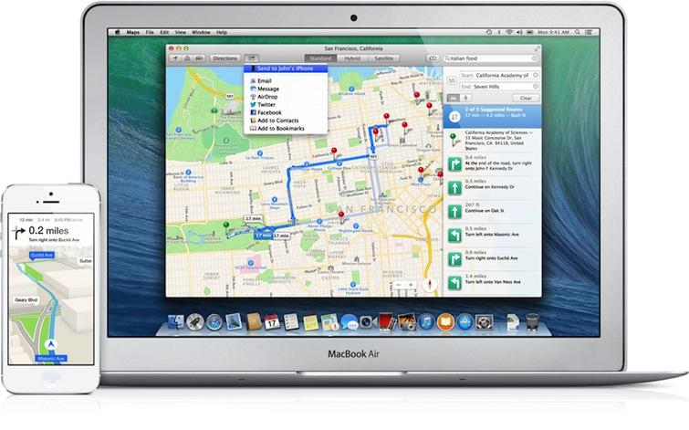
As Apple prepares its latest enhancements to Maps with iOS 7, Google has released its own major update for Google Maps on iOS. Here's how the two compare in location data and local search, our fourth segment looking at mobile maps.
5: Routing & traffic
As previous segments in this series have detailed, Apple's new iOS 6 Maps introduced cutting edge technology related to efficient 2D and perspective vector maps, as well as 3D visualizations of satellite maps, a feature Apple calls Flyover. In these areas, Apple is well ahead of the mobile apps from Google and Nokia, the existing market leaders.
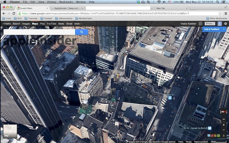
Apple's mobile iOS 6 Maps is even well ahead of Google and Nokia in the arena for 3D mapping visualizations using a full powered desktop.
On top, Apple will be bringing its own desktop class Maps app to OS X Mavericks, providing larger map views without the performance constraints imposed by mobile devices.
Apple's Maps also handle offline use much more efficiently. If you do any traveling where you work outside of the network service area, being able to efficiently work offline is a major feature.
For example, after going off the mobile grid on the way to the airport in Hamburg, Germany, Google Maps for iOS gave me nothing but pixelated mess of jagged lines well before I got there, while Apple Maps properly cached enough vectors show where I was, navigate the highways and read the street labels of the major roads.
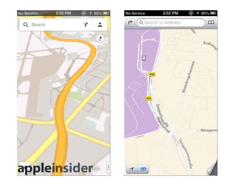
Google Maps fail rapidly, while Apple Maps continue to work for miles offline
At the same time, Apple's iOS 6 Maps doesn't provide its own transit information, relying instead on third party partner apps to deliver this. And in many reviews, Apple's new Maps have been criticized over misplaced map labels and inferior search results.
To see how well (or poorly) Apple's map labeling and location search stands up to competitors (and companion iOS 6 alternatives in the App Store, including Google Maps for iOS and Nokia Here), we conducted a series of tests to see how well each performs at finding and locating points of interest and (as will be detailed separately in a future segment) in providing driving directions and traffic information. You can skip the historical context of iOS 6 Maps below and jump to our comparison of iOS map apps on page two.
iOS 6 Maps was not Apple's first location project
Last fall's release of iOS 6 Maps wasn't Apple's first move into the business of maps and location-oriented technology. The company began laying the groundwork for location awareness and finding and labeling locations at least five years earlier. Within six months of launching the original iPhone, Apple added the beginnings of a location system to its Maps app, originally based on WiFi base station data compiled by Skyhook Wireless (because the original iPhone lacked hardware support for "real" GPS in the form of the satellite-based Global Positioning System).
In iOS 2, alongside the release of the App Store, Apple began recognizing the potential for misuse of location data and the need for protecting users' security from intentional or inadvertent mishandling by third party apps. It gave users the ability to turn location data off before it even launched the App Store, and forced app developers to ask the user for permission before accessing the device's location for any reason.
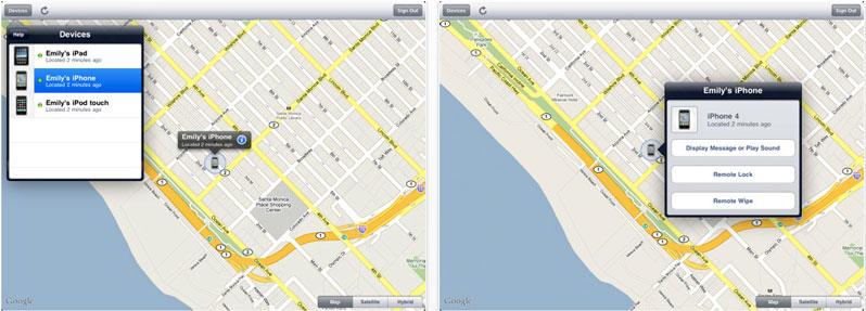
In iOS 3.0, Apple added remote location capabilities for MobileMe's new "Find my iPhone" feature, similarly protected via a user-secured account. It also introduced Core Location, a framework that enabled third party apps to develop turn by turn navigation apps.
In parallel, Apple also launched a new version of iPhoto in early 2009 that added geolocation awareness to photos on the desktop, a feature it named Places. Beyond just reading the geotag metadata of a photo and plotting it on a map, iPhoto also performed reverse lookup of place names from the latitude and longitude data, as Apple's Phil Schiller demonstrated at Macworld Expo. While Apple continued to use Google's map data, it was beginning to develop its own location database for Places.
At the same time, Apple also began acquiring location based mapping companies, including Placebase in July 2009. That startup's employees had been working on maps product before Google brought its own Maps to the web for free; Placebase then changed direction to offer a more customizable product to layer "private and public data sets" together. Former Placebase employees subsequently joined the "Geo Team" at Apple to work on a series of location-based initiatives in iOS and OS X, and in apps like iPhoto.
Apple continued hiring staff to work on maps, with one job posting in late 2009 noting, "we want to take Maps to the next level, rethink how users use Maps and change the way people find things. We want to do this in a seamless, highly interactive and enjoyable way. We've only just started."
By 2010, most of Apple's iPhone installed base now had GPS, but Apple's other products, including the iPod touch, all WiFi-only iPads and Macs, still relied on WiFi location. That spring, Apple began providing its own location information in place of data from either Skyhook or Google. It also began supporting iPhoto Places on iOS 3.2 for iPad.
And that summer, Apple released iOS 4 with additional security features related to location services, which it also enhanced to "define geographic regions and monitor when the user crosses the boundaries of those regions," a technology referred to as geofencing.
Apple also enhanced its Map Kit framework in iOS 4, adding support for map overlays to "provide a way to create more complex types of annotations. Instead of being pinned to a single point, an overlay can represent a path or shape that spans a wider region." Apple told developers, "you can use overlays to layer information such as bus routes, election maps, park boundaries, and weather maps on top of the map."
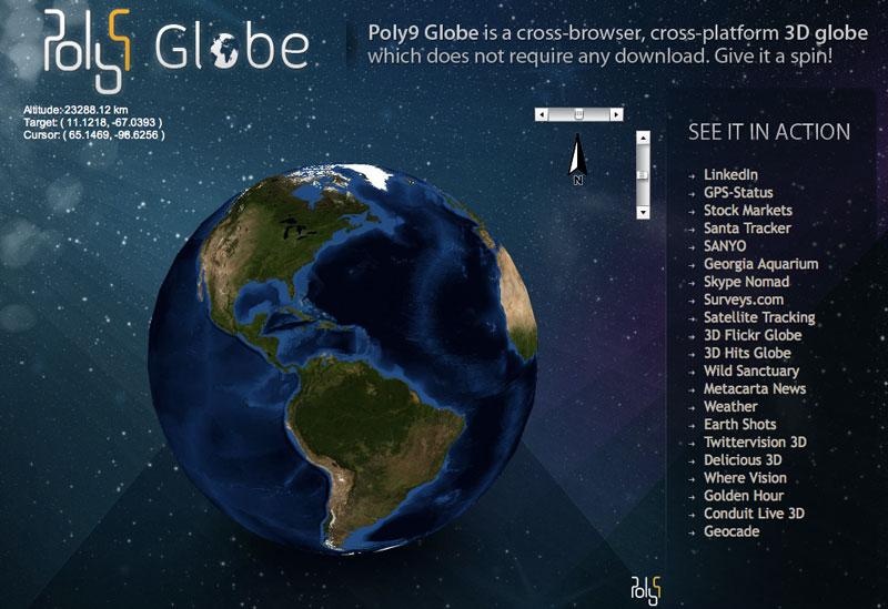
The company also acquired Poly9, a Canadian company that produced mapping products used by companies including Skype, which was later purchased by Microsoft. And through the end of 2010, Apple continued to hire new engineers related to mapping services, asking for candidates with "deep knowledge of Computational Geometry or Graph Theory" and posting listings related to "distributed image processing on a server cluster."
In 2011, the company announced in April that it was "collecting anonymous traffic data to build a crowd-sourced traffic database." The collected data sparked a controversy after users discovered caches of large amounts of data that were being unnecessarily backed up to iTunes, issues that Apple addressed with an iOS update in May.
Apple subsequently introduced iOS 5, which added new support for geofencing in location-based Reminders, a feature that later made its way to the Mac. This feature was an application of the Location Services and Map Kit enhancements Apple had first introduced in iOS 4.
Maps-gate, right out of the gate
When iOS 6 arrived, it should not have been huge surprise that Apple was now serving its own maps within the app, rather than Google's. At the same time, however, a variety of features that users commonly associated with Google Maps were actually Apple's own work.
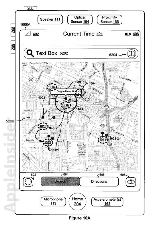
This included the original iOS Maps user interface (which Apple patented) and the Map Kit frameworks developers use to interact with it and to locate places and draw points of interest, bus routes, arbitrary regions and other annotations on a map. Developers were fully aware of this, but many users did not seem to be.
However, after years of internal work, the new iOS 6 Maps was released last fall without full and official recognition by Apple that some elements of the new product were brand new and still being completed, particularly its Flyover 3D satellite renderings, which were only finished in a variety of U.S. cities.
Critics, unaware of Apple's years of work invested in Maps (many of whom apparently thought that that iOS 5 Maps was entirely a Google product) virtually ignored all of the new product's innovations to focus on four things: Flyover glitches in areas that hadn't been fixed (such as the Brooklyn Bridge), the lack of Google's Street View, the lack of integrated transit data, and a variety of improperly located or otherwise incorrect points of interest.
Maps, a primary strategic product for Apple in iOS 6, rapidly became one of the most ridiculed and dismissed products in recent history. Pundits' contempt for the new Maps grew so loud and scathing that Apple's chief executive Tim Cook issued an apology for any inconvenience to users and recommended a variety of alternative mapping tools in the App Store and on the web for iOS 6 users.
It has since been widely reported that Scott Forstall, then acting as the head of iOS development, refused to make the public apology himself. That was said to be the last straw in what has been characterized to be a series of contentious management issues, and resulted in Forstall being stripped of his responsibilities. Management of the Maps team has now been delegated to Eddy Cue, who runs the rest of Apple's online services including iCloud, iTunes and the App Store, and the Siri service integrated into Maps.
Apple Maps' biggest potential flaw: labeling and search
Of the top four issues nagging Maps, location labeling problems appear to be the most troublesome and significant. Apple has quickly updated many of its initial 3D Flyover glitches and began expanding the feature (which is useful, but not really necessary to use Maps or its conventional satellite layer; note that it isn't supported at all on iPhone 4 hardware) to international cities; Google's Street View is already accessible via other apps, and from the web; and a variety of Transit apps have already appeared.
However, if iOS 6 Maps can't reliably find and accurately locate businesses and other points of interest, it would represent a fatal flaw, unlike the other relatively easy to fix problems that critics have highlighted.
Users can simply turn off 3D Flyover and see standard satellite images, and third parties can rush in to fill the demand for transit, but if Maps can't locate known places, it would be very bad news for Apple and something that third parties can't really address on their own. If the problem is bad enough, developers might even opt to link their apps to Google's app rather than Apple's Maps app, hurting adoption of the new software.
At the same time, Apple's investment in integrating 3D Flyover maps right into its Maps application is both novel and useful. When navigating the historic center of Munich, for example, Google's depiction of skinny lines isn't very helpful, and there's few labels on the map to help with orientation. Apple's standard Maps are significantly more readable and better labeled.
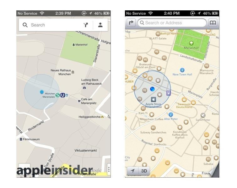
Munich in 2D
However, enter Flyover mode and you can immediately see where you are in a virtual 3D model of the labyrinth of streets and alleys, guided by the realistic appearance of buildings and open spaces that don't translate very well to the standard grid of street maps popularized by Google on the web. And if there's some question about whether a road is passable by car or how it intersects with another street, Flyover provides an interactive model for examining your intended path or general surroundings.
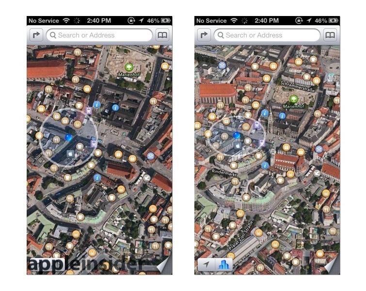
Munich via Satellite and Flyover
How maps apps compare in labeling and search
As alluded to in previous segments, Apple's new Maps doesn't attempt to simply duplicate the status quo of the features available in competing products from Nokia and Google. But in the area of search and locating points on the map, the requirements are pretty obvious: there has to be enough detail in map labels to be useful, search has to turn up useful results, and addresses have to be located properly.
Apple's focus on simplicity and the often very barrenly clean appearance of the iOS 6 Maps app seems to sometimes go overboard in the realm of labels. Additionally, the dynamic nature of Apple's labels, with appear and vanish in parallel with dynamic nature of the maps themselves as you zoom and pan around, makes it difficult to accurately capture and represent the overall experience with static screen shots.
As you browse the map, highlighted locations (those that appear by default, rather than as search results) may appear rather sparse and seemingly selected at random. But they're not, as explained below.
Google (via the web, shown below, in iOS 5 Maps and its new native Google Maps app) often shows many more locations by default, but many of these are curiously unimportant listings for home businesses (the results of Google allowing people to contribute their own locations). Google Maps are also dynamic in some respects, sometimes in ways that are misleading.
The image below depicts San Francisco's major Market Street thoroughfare simply disappearing for a block in front of Safeway near Church Street, and again at Guerrero, a street that also itself vanishes north of Duboce. None of these missing roads are actually missing, and if you zoom in and out enough, they are eventually redrawn correctly. Google's Map labels also sometimes appear or vanish at different zoom levels.
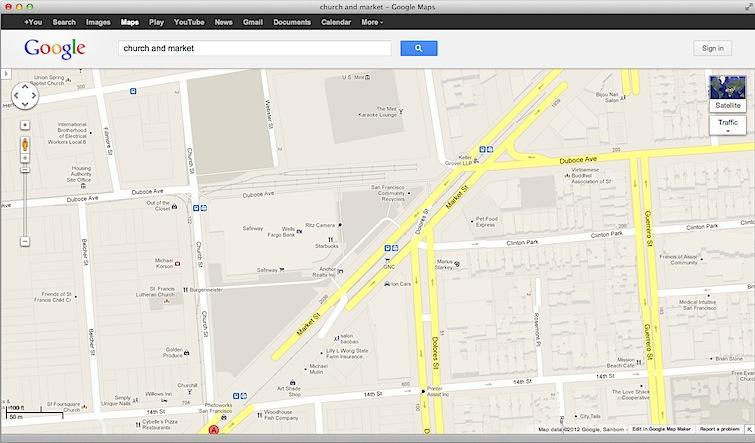
Google Maps
Nokia's web app and native "HERE" iOS app (which are essentially identical in their data) both show simple and plain looking maps. They provide very sparse labels, in some places showing nothing labeled at all.
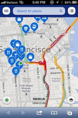
Nokia HERE
MapQuest's app is all about search, and presents almost no business labels on the map by default (which are also quite low quality). If you're looking for useful labels, its a two horse race between Apple and Google.
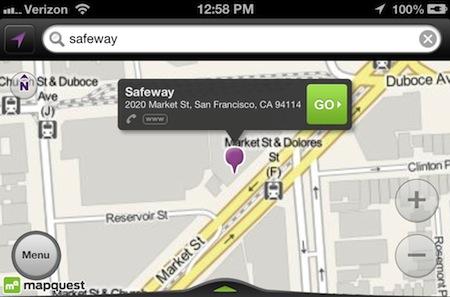
MapQuest
A San Franciscan example of how iOS 6 Maps work, and how they've changed
It's not always readily apparent why Apple chooses to label specific businesses on the map. When viewing the same Safeway shopping center in the middle of San Francisco (as depicted by Google, above), the only label was for Jamba Juice. No amount of panning or zooming on an iPhone could force Maps to identify that this 3D modeled building is, in fact, mostly a grocery story with some much smaller retail businesses around it, unless you specifically search for it.
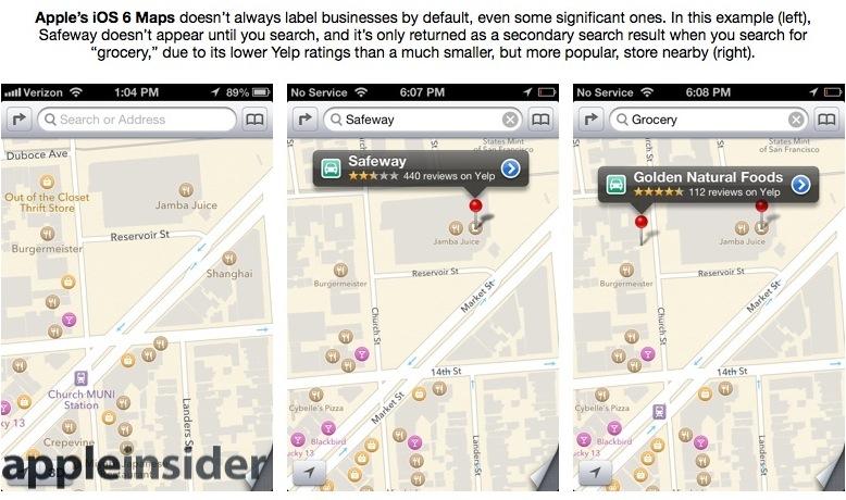
Apple Maps
Apple's Maps will locate the main store if you searched for "Safeway," or generically for "grocery store", but if you only searched for "grocery," you'd initially only get pins at the smaller markets located around it.
It appears that Maps' results were (and still are) heavily weighted to Yelp reviews; initially, the only locations that showed up when browsing the map were spots with more than three stars (with some exceptions: gas stations are often 2 stars in Yelp but most do show up by default, likely because their utilitarian importance is greater than reviewers' often negative opinions of them).
Safeway only has 2.5 Yelp stars, while the smaller Golden Natural Foods across the street has 4.5 stars. Not only was the smaller store featured on the map before even searching, but it was also more likely to show up in generic search results. If you're wondering why only specific businesses are featured on the map or in search results, it's probably related to the local public opinion reflected in Yelp reviews.
In the first couple months of iOS 6, Apple updated labels in this area so that Safeway is often now labeled by default. It also now appears as a graphical search result when you search for either "grocery" or "grocery store."
Comparing Google Maps' points of interest labels for the same location
In iOS 5 Maps (using Google's map data), this shopping center was originally depicted with the same labels that appeared in Google's web maps (back in October when we first looked): the Safeway was labeled twice, along with a Wells Fargo ATM inside it and the Starbucks, (now shuttered) Ritz Camera and Jamba Juice outside in the same complex (although those businesses are not correctly labeled; Jamba Juice is north or Ritz, not adjacent to Starbucks.
Google also labeled a "Safeway Pharmacy" and GNC store in the complex, but it pinpointed the pharmacy on the sidewalk (Apple didn't label the grocery store's pharmacy as a separate business, but does return 'Safeway' if you search for "pharmacy") while the GNC was labeled by Google as being located on the train tracks in the middle of Market Street. Apple labels GNC as being in the center's parking lot. So both companies are a bit sloppy with precise placement of their labeling.
If you're looking for a business, such moderately sloppy labeling probably won't prevent you from finding it. In other cases however, Google pinpointed businesses so far away from their true location that it would be impossible to find it without asking somebody for help.
For example, Google Maps also located "Canela Bistro Bar" in the middle of the street near Church and Market, but that restaurant is actually located three blocks down Market Street. Search for "Canela," and Google showed it in the Safeway parking lot, while Apple correctly located it with both labels and search. Canela is highly rated in Yelp, so Apple shows it as label by default. Nearly a year later, Google Maps now locates Canela in the right place.
Both Apple and Google listed "Ion Cars" (or Enterprise rental car) across the street from Safeway, a now shuttered (but once highly rated) car rental outlet located in a since story warehouse building that was torn down last year and is now a large, eight story condo complex, albeit still under construction.
Neither Apple nor Google depict the new construction in their 3D grey building models or their satellite imagery (including Flyover, Google Earth or Street View), but it is a bit much to expect the two companies to keep their global satellite images instantly up to date with such recent changes.
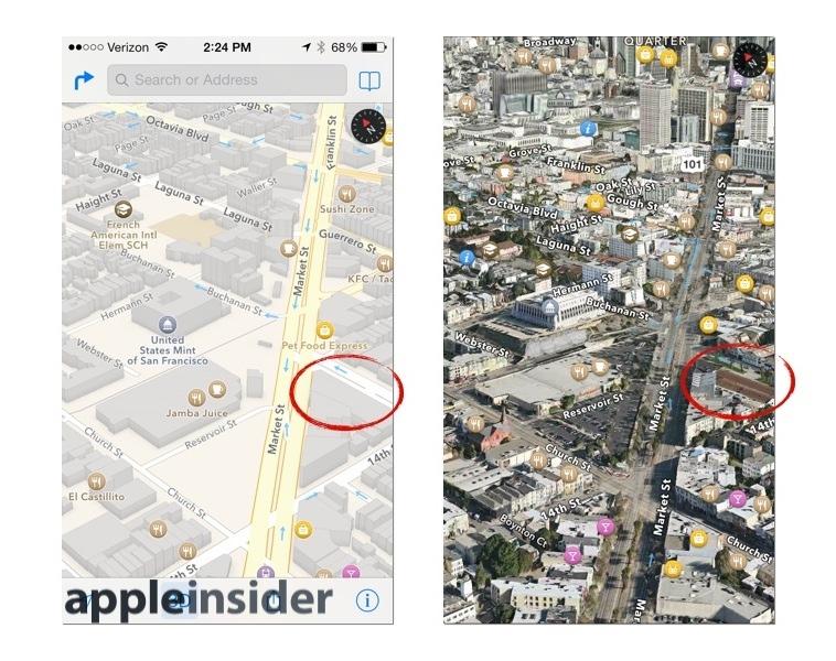
Apple's Standard and Flyover views
Note the differences: Apple's 3D models (above left) convey massing more accurately than Google's (below left); you can tell, for example that the U.S. Mint sits high above Safeway on a plateau of rock. And Apple's Flyover satellite views (above right) convey depth better than either Google's flat satellite maps (below right). Apple's labels are also clearer, particularly as you animate the map with your fingers.
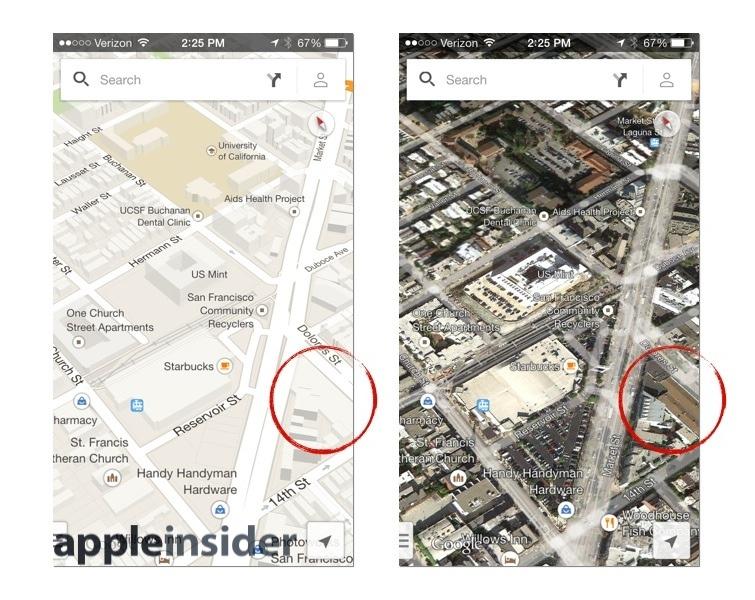
Google's Standard and 3D Satellite views
Google's Street View (below left) is sometimes useful, but much slower to navigate than Flyover. And its imagery from the separate Google Earth app (below right) has worse labeling than standard Google Maps. The static image from Google Earth looks nice, but isn't very easy to navigate around in and there's very limited options in the viewing angle.
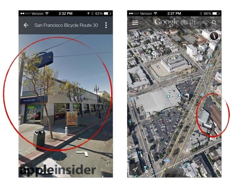
Apple's Standard and Flyover
Apple's Flyover does a much better job of visualizing an area, and is much easier to explore and orient than Google's very touchy Satellite and Earth views, both of which are locked to specific angles and sporadically jump in and out of zoom levels, making them frustrating and irritating to use.
If you were looking for this particular Safeway on the map, Apple lets you jump into Flyover and immediately recognize a grocery store building; you can even make out the Safeway sign. Google Maps gives you a satellite image in forced (but flat) perspective, and offers to launch Google Earth, which gives you a view that isn't much better but is much more difficult to explore around in. You can enter Street View, but this mode is slow, shows only one frame at a time as you click towards a given destination, and sometimes the very thing you're looking for is blocked by a truck or trees.
Back to labels in general: Google correctly labeled the U.S. Mint located behind Safeway, but also incorrectly labeled the same spot as being The Mint Karaoke Lounge, which is actually around the corner on Market Street. A search for "mint" or "mint karaoke" always dropped pins in the same wrong place, as Google refused to locate the popular bar just around the corner where it actually is. Nearly a year later, Google now shows the correct location of The Mint Karaoke Lounge as iOS 6 Maps did last year.
In the other direction, Google labeled an private attorney, architect, insurance agent, salon and an artist as all being across Market Street. Google also located a hardware store, Photoworks (a print shop) and the Apothecarium (a marijuana dispensary), but depicted them all as being in the middle of the street, rather than in their proper location. These errors have since been fixed in Google Maps.
Apple doesn't label a lot of random private businesses, instead highlighting only ones you're likely to be looking for, again based on Yelp data. It also initially didn't consistently label every landmark. At some zoom levels, the U.S. Mint wasn't identified unless you zoomed in or tapped on it. It now appears to be labeled correctly by default. Apple's Maps also correctly placed the other Mint (a popular karaoke lounge with 3.5 stars in Yelp) where users could actually find it.
Across the street Apple initially labeled the prominent California Volunteers Monument, but, interestingly, only when looking at the map in Satellite or Flyover view. Like the U.S. Mint, it now appears by default even in Standard view.
Apple also correctly pinpointed Photoworks and the hardware store, but also pointed out M&L Market, a very popular sandwich shop with 4.5 stars in Yelp (that Google does not label). Both Apple and Google can find it if you search by name or by "sandwich."
On the other hand, if you search for "marijuana," Apple will also correctly locate the otherwise unlabeled Apothecarium for you (it too has 4.5 stars in Yelp, indicating that Apple filters what it shows by default based on more than just Yelp stars).
Apple's leverage of Yelp tends to label the map with places other people find useful or interesting, but they weren't alway accurate or up to date. A block up Market Street, Apple initially labeled (and 3D modeled) a Shell gas station across the street from a 76 Station that's labeled as a car repair shop. Both were closed; the Shell has been demolished for some time, while the 76 was more recently shuttered and demolished.
If you looked at iOS 6 Map's Yelp reviews of the Shell, a user reported that it closed in 2007, but Apple still had it labeled on the map. Entering Flyover would also help clarify that there's no gas station to be found here anymore. Both labels are now gone, having been updated over the past few months.

Shell was labeled last year, even though Flyover shows it an empty lot
Google listed the vacant Shell lot as being "Reality SF Office," with an address of an agent across town and, (incorrectly) a photo of the building next door (a music venue). This might be useful if you wanted to buy the site of the old gas station, but that doesn't seem likely. Google also labeled the 76 as an ATM, although it is identified (on the web, but not in the old iOS 5 Maps app) as being permanently closed. Like Apple, Google has removed these outdated labels in the last few months, indicating that both companies are regularly updating their map data.
Via Google's Street View in the old iOS 5 Maps app, you can see that the Shell is actually an empty lot, although that view also shows the 76 as being open and in use. Apple's Flyover similarly showed the Shell as being an empty lot (despite having a 3D model of it in standard view) and similarly depicts the shuttered 76 as still apparently being open. So despite both updating their map labels, there's more of a delay in updating satellite, Street View or Flyover imagery.
Both Apple and Google have updated their map labels for this area more than once in the last several months. Apple had fewer obvious errors to start with; it has since removed labels for the two gas stations that were closed (the Shell is now labeled "Delancy's Christmas Trees," the only current use of this lot). Google has also cleaned up its location errors, moving Canela, The Mint and Photoworks to the correct locations.
But of the other significant businesses on this intersection, Google initially presented the most errors and omissions. In addition to showing the wrong location for the Mint, it also showed the Pilsner Inn in the middle of the street (or across the street), and didn't label the newer, hip bars Blackbird, Churchhill and The Residence at all on the web (although two of these are labeled in the Google maps native app). In contrast, Apple has all these bars in the right places since iOS 6 Maps first shipped.
Looking for a place to eat? Google still doesn't show M&L, but it also fails to label the main restaurants on this corner, including Chow, Miyabi Sushi, Chilango, Jasmine Garden, Cathay Express, and Casa Mexicana on the web (in the Google app, two of these six are actually labeled). If you search for "food," Google's app will show you these results however. Google is better at search than labeling, whereas Apple is often better at labeling (thanks to Yelp) but often less adept at search (particularly if you're searching for a misspelled phrase).
There are four other food locations that both Apple and Google correctly label on this corner, and one that Google shows that Apple doesn't: Thorough Bread bakery. This location only shows up in Apple's Maps when you perform a search for "bakery," despite being highly rated on Yelp. Because it shares the building with another restaurant, it appears Apple fails to label highly rated locations by default if there's limited room for a label, at least in some cases.
While Apple Maps was castigated last year for having terrible labels in the wrong places, in our searches it was Google Maps that failed to label the most popular spots and often labeled them incorrect places. It appears that Apple's Maps has played a big role in pushing Google to clean up its act and improve its map data, given the rapid improvements Google has made over the past year. So even if you live in an area where Apple Maps' labels aren't as accurate, it has likely pushed Google to enhance its own maps, which you can also now use on iOS.
Note that this particular neighborhood is the urban backyard for both firms, as both companies shuttle their employees up to San Francisco with charter busses that stop nearby. There's no excuse for Google's map data to have been so poor so close to home, but its great to see both companies have aggressively worked to improve their labeling over the past year.
Looking for location flaws in Apple Maps
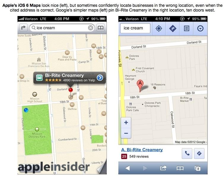
Traveling down Dolores Street, I finally found a jackpot of incorrect business labels in Apple's Maps: the popular Bi-Rite Creamery was located on the wrong part of the block (despite having the correct address in its Yelp review), while across the street the popular Tartine Bakery has a shopping icon rather than food icon. Next door, there are two Delfinas: a restaurant and a pizzeria (this is correct).
But when I searched for "Tartine Bakery," it pinpointed Delfina next door on 18th, not its correct location on the corner of Guerrero. This is odd because Tartine has an address (in Yelp) of 600 Guerrero; it's not even on 18th. And when I searched for "ice cream," it pinpointed the incorrectly placed icon for Bi-Rite Creamery, rather than its correct address further down the block. Why is Apple's Maps unable to find these two very popular businesses, despite having their correct addresses listed in Yelp? It's hard to say.
Six months later, Apple Maps still has all of these errors, with no corrections having been made to these popular locations. In fact, things are slightly worse: Delfina is now labeled incorrectly Tartine Bakery, while the actual bakery location is simply labeled as Tartine. These aren't obscure restaurants; they are some of the most famous places in the Dolores Park area, a popular mecca for San Franciscans, and particularly the hipster population outfitted with smartphones (although in reality, finding Tartine or Bi-Rite is simply a matter of spotting the long lines out the door and down the block).
Despite Apple's strange location errors with business placement, Maps does often provide enough information to find these businesses, if you're looking. Google presented (in our testing) more wrong information, but also a lot more trivial junk you're unlikely to be looking for (mostly personal small businesses). While often better at general search (particularly when searching for misspelled places), Google also frequently labeled search results at the wrong locations, more often than Apple in the tests performed.
Other apps are often far worse than Apple Maps for finding points of interest
The search-oriented MapQuest app doesn't offer an improvement over Apple's labels or search results. It also located the closed car rental place and one of the closed gas stations. It was also unable to find our ice cream store unless we searched by name (although it then located it correctly). It correctly located Canela by name and M&L when we looked for "sandwich," but refused to find marijuana, and when we searched for Mint or Mint Karaoke, it jumped to South Dakota.
Nokia's HERE (the company's native iOS maps app) scored the worst in both labels and search. Rather than labeling anything, Here simply drops icons around the map that you have to click on to see what they are. Clicking on food (knife and fork) icons, Nokia located various things on this corner that have been closed for a very long time, including the shuttered Home and Azteca restaurants and the Metro and Transfer bars that haven't been around for years.
Search results were similarly outdated or just wrong. Nokia's labeling is so bad that the app is essentially useless for finding anything via browsing or search (at least in San Francisco, which is admittedly far from most of Nokia customers). There are some useful aspects of the app in terms of finding routes, however, as we'll examine in the next segment pertaining to traffic and directions.
Heading downtown, I tried to set up a difficult route by asking for directions between Union Square's Niketown and the Apple Store. These two locations appear to be just a few blocks apart on the same street, but Stockton is currently under construction for the Central Subway and closed to traffic. I'll discuss the issues of routing around closed streets later, but efforts to locate the businesses were difficult enough to stump Google Maps by themselves.
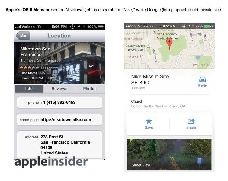
A search for "Nike" by Apple Maps returned Niketown (which was open last fall when we started the testing), but Google Maps would only provide search results for anciently historical "Nike Missile Sites." Now that Niketown has closed, Google presents the store in its search results, a little too late to actually be helpful.
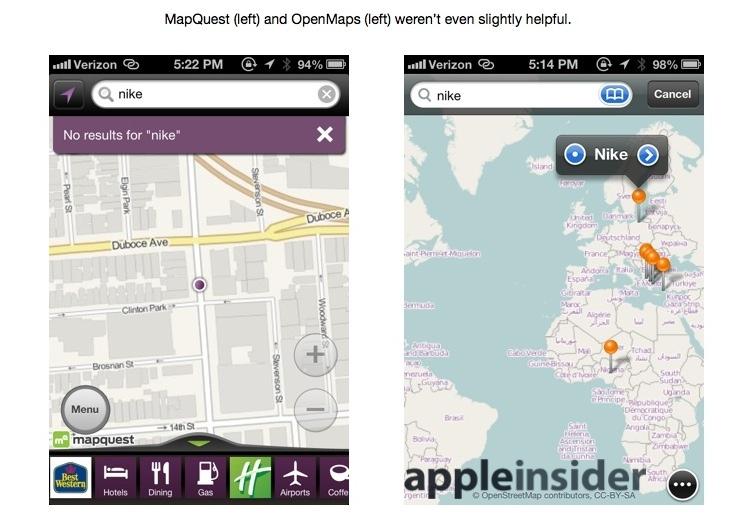
Waze, Nokia and (of course) Yelp could also find Niketown, but other mapping apps were even worse than Google. OpenMaps jumped straight to Poland while MapQuest couldn't find anything. When we explicitly searched for "Niketown," OpenMaps jumped to Las Vegas and MapQuest leapt to New York City.
The often nonsensical search results and poor labeling provided by many alternative mapping apps makes it curious why the tech media gleefully regurgitated news that Apple's chief executive Tim Cook had apologetically recommended various other App Store mapping alternatives, when they should have known that many of these were worse than Apple's own Maps, not better.
Apple and Google have lots of work ahead in maps
In particular, it is rather bizarre how bad Google Maps' data has been over the past several years and how nobody has noticed this, compared to the opposite reaction to Apple Maps last fall, when users scoured the globe for spots where Apple's Maps were useless or flawed.
It has been in Google's interests to demonize Apple Maps as being terribly flawed. The introduction of Apple's own Maps app for iOS took away Google's default advantage and reduced Google's own maps to being used by a minority of users, who must go out of their way to download it.
Google's place and label information appears to have made big strides over the past year as the search giant tries to win back usage among iOS users, and as the company has tried to bring its iOS app into parity with its Android version. However, there's still a long ways for Google to go in matching the useful Flyover visualizations, often newer satellite imagery and the superior multitouch savvy of Apple's Maps.
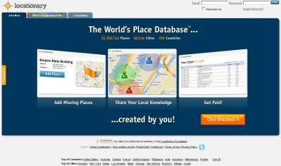
At the same time, Apple has lots of map data to adjust and correct, a similarly large job. The recent acquisitions of HopStop and Locationary acknowledge as much.
Apple's Maps accuracy closely mirrors that of Yelp
In large measure, Apple Maps' reliance on Yelp for data means that in areas where Yelp is strong, Apple's Maps is too. There are, however, areas where Yelp data is weak or simply wrong, and additional areas where Yelp data is correct but Apple's placement of location is off by several doors down the street. Google's map data is less connected to another service because it largely handles its own location data, but the quality of that data set varies considerably, ranging from messy to comically bad in some places, while having improved significantly in others, particularly over the past year.
So far, in looking at just three intersections in popular areas in the shared urban backyard Apple and Google, Apple has labeled two wrong locations and given one wrong search result (despite presenting correct addresses for both) and labeled three closed locations on the map (one of which was identified as closed; all three closures have since been updated).
Google incorrectly located 5 businesses on the map, returned two wrong search results for popular businesses (both off by more than a few door's down), and listed two closed locations on the map (one of which was identified as closed; both of which are now corrected).
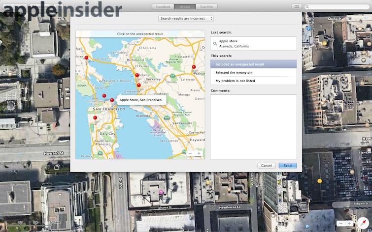
Google's map labels are also littered with duplications and lots of minor home business listings. Apple's map labels are generally limited to favorably reviewed businesses (with at least 3 stars), important sites (such as gas stations) or interesting landmarks you might see and wonder what they are as you travel past (Apple beats Google 2 to 1 in that regard). Given that Apple is now adding new reporting tools to its upcoming Maps app for OS X Mavericks, it will be interesting to see how rapidly the company reviews and updates users' error reports.
The upcoming iOS 7 introduces a series of improvements and refinements to Apple's Maps app, but the mapping data behind them is identical. That means users who live in an area where Yelp data is poor or missing will continue to have limited success with labels and search.
Fortunately, the availability of new competition in iOS Maps has sparked Google into action, resulting in a significant wave of location updates in many places. The winner in this corporate mapping battle is the end user, who wasn't being well served by Google Maps' sloppy and incorrect location data over the first five years in iOS. Now that there are two strong players for mapping in iOS, mapping options for iPhone and iPad users have improved more in the last several months than ever.
iOS 6 users currently have a choice of Apple, Nokia and Google Maps, each of which has its own strengths and weaknesses. In the area of map labels and search, Apple's rates neck and neck with Google in areas where Yelp data is useful, but falls behind in regions where Yelp is less widely used. The next segment in this series will look at the range of iOS apps providing traffic and driving directions, and how well Apple's own Maps app stacks up against the competition.

-m.jpg)

 Bon Adamson
 Marko Zivkovic
 Amber Neely
 Malcolm Owen

 Christine McKee


-m.jpg)


67 Comments
As with OS' design, software backing, and patent applications*, in the future Google will do nothing except copy Apple in maps. And all their fans (paid or otherwise) will do is lie, scream, and pretend otherwise. [B][SIZE=5]*[/SIZE][/B] [IMG ALT=""]http://forums.appleinsider.com/content/type/61/id/28686/width/500/height/1000[/IMG]
Another maps update from Google? Well, thank-you [B]APPLE.[/B] I don't recall getting this much attention from Google just a short while ago...
What Apple's Maps app needs is to borrow a little from Google maps when it comes to secondary roads. Look at the map of the Hamburg airport. With Google at least you can see the secondary roads, although they're not labelled. Apple's Maps, on the other hand, label the roads but make them so light that they're impossible to see.
From Tallest - Plain and simple drawing...
reminds me of one of those "spot the difference" drawings we used to get in magazines and puzzle books years ago. "Look the third knuckle on the right has a scar, missing on the other"
What percentage of Google Maps users are running on Apple Devices as opposed to Android? Following from that, what is the split on revenues Google generates from its maps from the Apple v the rest?