Although Sen. Schumer didn't use the phrase "spy planes" in his letter to Apple chief executive Tim Cook and Google CEO Larry Page, a press release issued on the senator's website regarding the matter did mention the term and described the two company's efforts as utilizing "military-grade" hardware.
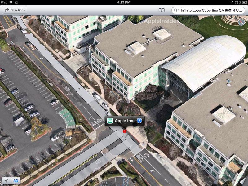
The senator noted that, while services like Google Maps have in the past used satellite imagery, the new imaging technology allows for resolution of up to 4 inches. While Sen. Schumer is referring to high-resolution photographic equipment, at least one of the assets Apple acquired in developing the new iOS Maps app, a mapping company called C3 Technologies that was once part of Saab AB's defense arm, does use once-classified military targeting tech to achieve impressively realistic interactive maps.
“Barbequing or sunbathing in your backyard shouldn’t be a public event. People should be free from the worry of some high-tech peeping Tom technology violating one’s privacy when in your own home,†Sen. Schumer said. “High resolution 3D mapping may have some very useful and practical applications, but the technology that is reported to be used by these companies brings a level of precision that has never before been utilized for public purposes. It raises important privacy questions and individuals have a right to know when their homes and communities are being mapped – and whether highly detailed images of them and their homes will wind up published online. By using powerful cameras that can see through your windows and display details of sensitive security sites, Apple and Google will have access to private and sensitive images. It’s imperative that these companies disclose their plans for protecting privacy of both individuals and sensitive infrastructure, their publication intentions, and their plans for including public consent in the mapping process.â€
Apple announced its new proprietary Maps app for iOS last week finally putting a cap on rumors that the company was ready to launch a product that combined the technology of over two years worth of mapping company acquisitions. Google beat the iPhone maker to the punch and revealed their own 3D mapping software upgrade earlier in June.
While the world's militaries rely on satellite imagery that is highly-restricted, Google's system gets by with digital overlays of photographic models taken from planes the company owns. Apple's "Flyover" tech uses a similar system that renders 3D recreations in real time.
The letter in full:
Dear Apple and Google,I write today over the recent revelations that your companies are using highly sensitive photography equipment to take pictures of cities and towns across the country for your respective mapping products. These disclosures are potentially troubling, and I request that the privacy and security of Americans remain your top priority as you deploy new mapping and imaging capability.
It has been reported that some of these sensitive cameras can take pictures of objects up to four inches wide. I fear that this clarity may allow your mapping programs to take detailed pictures of people in intimate locations such as around a pool or in someone’s backyard. People on Long Island or in Buffalo have a reasonable expectation of privacy when they decide to have a barbeque on their back deck and would prefer to retain the option of deciding whether they should be photographed on their property. They should not fear that your planes will be overhead taking detailed pictures of their private events.
Detailed photographs could also provide criminals and terrorists with detailed views of sensitive utilities. On current online maps, many power lines, power sub stations, and reservoir access points are visible only at low resolutions. However, if highly detailed images become available, criminals could create more complete schematic maps of the power and water grids in the United States. With the vast amount of infrastructure across the country, it would be impossible to secure every location.
Therefore, I request that your mapping programs include three separate privacy and security provisions:
1) Provide notification to communities as to when you plan to conduct mapping
2) Automatically blur photos of individuals who are captured, and give property owners the right to opt-out of having the company map their homes
3) Put protocols in place with law enforcement and local municipalities to ensure that sensitive infrastructure details are blurred from published maps
I hope that you would be willing to work with my office on this very important issue and ensure the security and privacy of all Americans.
Apple and Google have yet to respond, though likely precautions may be akin to those seen in Google's Street View which blurs out license plates and other imagery deemed sensitive in nature.
“We must strike the proper balance between privacy and technology,†Sen. Schumer said. “And while the use of this technology may well have very functional and important uses, we need to make sure that reasonable protections are in place to protect individuals and the public.â€
 Mikey Campbell




-m.jpg)



 Wesley Hilliard

 Christine McKee
 Malcolm Owen
 William Gallagher
 Andrew Orr




-m.jpg)


71 Comments
Schumer is such a tool.
Time for the Geofencing Opt Out Bill
Schumer is such a tool.
One of the biggest in the shed.
I'm also hearing concerns that we're thinking about banning 'fire' and 'electricity' for being able to create 'light'.
Technically that's an invasion of privacy for those in the dark...
I thought it was a very cordial and common-sense letter. While I don't think it's going to be much of an issue, I can see some people getting very upset if they are caught nekid in there backyard. The use of hi-res satellite imagery could aide terrorist, but again, they could get that information elsewhere. Either way, it's good to think about these types of things and something that government should be thinking about.