Apple Maps gains public transit directions for Detroit/Windsor area
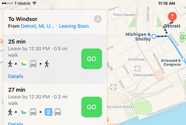
Apple this week updated its Maps apps for iOS and macOS with public transit directions for Detroit, Mich., as well as the neighboring Canadian city of Windsor.
Apple this week updated its Maps apps for iOS and macOS with public transit directions for Detroit, Mich., as well as the neighboring Canadian city of Windsor.
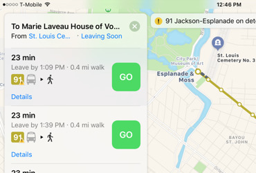
Apple has once again expanded the availability ot public transit directions in its Maps apps for iOS and macOS, this time brining them to New Orleans a few weeks ahead the city's annual Mardi Gras festival.
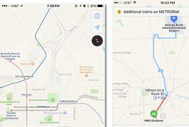
In time for Super Bowl LI, Apple on Sunday expanded Apple Maps transit data to include regional and metropolitan pubic transportation services in the Houston, Texas, area.

A good portion of the U.K. mass transit system, including National Rail, has been added to Apple Maps a week after the company added Salt Lake City in the U.S.

Ahead of an official debut scheduled to arrive with iOS 10.1 later this month, Apple on Wednesday activated the Apple Maps Transit feature for major metropolitan areas in Japan, including Tokyo and Osaka.

A year ago, Apple launched Transit directions in iOS 9 Maps, but so far there's only a limited number of cities worldwide that support the new feature. Here's why.

New cities with Apple Maps transit data continue to be added on a regular basis, with the town of Portland, Ore., the latest to enter the fold, on the heels of Montreal and Austin.

Days before the South by Southwest festival is set to kick off, Apple Maps has added public transit information to the host town of Austin, Tex., benefitting the tens of thousands who will descend upon the city.

As expected, Apple announced transit directions integration are coming to the Maps app in iOS 9, featuring multi-modal routing, rail line information and Siri integration, among other functions.

{{ summary }}
 Roger Fingas
 AppleInsider Staff
 Mike Wuerthele
 Mikey Campbell
 Daniel Eran Dilger
 Neil Hughes