In an update to the Apple Maps webpage on Friday, Apple announced its camera- and sensor-laden mapping vans will hit the streets of Spain and a trio of U.S. states this month.
According to the Apple Maps vehicles webpage, Apple began surveying operations in Spain on Monday, focusing on the Biscay province.
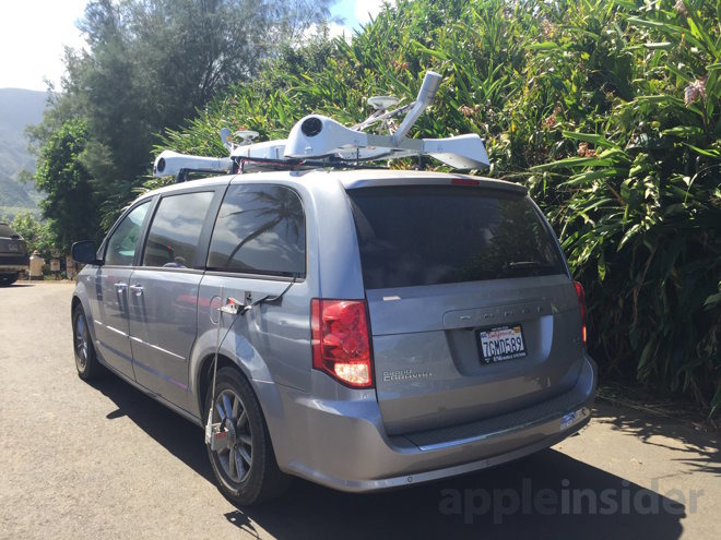
Mapping vans equipped with multiple high-resolution cameras, LiDAR arrays, GPS, distance measuring machinery and other advanced hardware are scheduled to gather information in Arratia-Nerbioi, Busturialdea, Durangaldea, Enkarterri, Greater Bilbao, Lea Artibai and Uribe-Kosta through Aug. 13.
In the U.S., July marks the start to Maps vehicle operations in New Hampshire, Rhode Island and Vermont. Apple is also moving into new areas in Arizona, Illinois, Maryland, Massachusetts, Michigan, New Jersey, New York, Pennsylvania, Texas and Washington.
In the newly added states, Apple mapping vans will be cruising the streets of the following cities:
- New Hampshire - Carroll County, Coös County, Grafton County
- Rhode Island - Bristol County, Kent County, Newport County, Providence County, Washington County
- Vermont - Addison County, Caledonia County, Chittenden County, Essex County, Franklin County, Grand Isle County, Lamoille County, Orange County, Orleans County, Washington County
Apple notes information gathered during mapping van excursions will be used to enhance Apple Maps, with some of the data finding its way into future updates of the mapping app. As per the company's privacy guidelines, license plates, faces and other identifying information will be blurred in published images.
Apple's mapping vans were first spotted in the San Francisco Bay Area in early 2015. At the time, some theorized the vehicles were part of Apple's autonomous vehicle program, Project Titan. The company attempted to dispel those rumors by publishing the Apple Maps vehicle webpage in June of that year, later labeling the vans with "Apple Maps" indicia, but speculation that data will be applied to self-driving car systems persists.
How Apple intends to use the imaging data in Apple Maps has yet to be revealed, though it is assumed the company is preparing its own version of Google's Street View technology. Alternatively, the information might be used to improve Apple's 3D Flyover feature, perhaps employing augmented reality tools powered by the forthcoming ARKit platform.