Apple started implementing indoor mapping data with iOS 11, offering users a new navigation aid for major airports and large malls. While rollout has been slow, the company on Wednesday compiled a list of the 43 indoor locations where users can take advantage of the feature.
Included in an update to its iOS Feature Availability webpage, Apple names the 34 airports that currently boast indoor mapping support in iOS 11.
As seen below, most airports are located in the U.S., but Apple does include a few major international hubs like Berlin Tegel and Vancouver International.
Indoor Maps Airports:
- Amsterdam Airport Schiphol AMS
- Baltimore/Washington International Thurgood Marshall Airport BWI
- Berlin Tegel Airport TXL
- Berlin Schönefeld Airport SXF
- Chicago O'Hare International Airport ORD
- Chicago Midway International Airport MDW
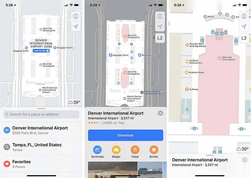
- Denver International Airport DEN
- Detroit Metropolitan Wayne County Airport DTW
- Edmonton International Airport YEG
- Geneva Airport GVA
- Hong Kong International Airport HKG
- Houston George Bush Intercontinental Airport IAH
- Houston William P. Hobby Airport HOU
- Indianapolis International Airport IND
- Jacksonville International Airport JAX
- Las Vegas McCarran International Airport LAS
- London Heathrow Airport LHR
- London Gatwick Airport LGW
- Los Angeles International Airport LAX
- Orange County John Wayne Airport SNA
- Miami International Airport MIA
- Minneapolis-Saint Paul International Airport MSP
- Nashville International Airport BNA
- New York John F. Kennedy International Airport JFK
- New York LaGuardia Airport LGA
- Newark Liberty International Airport EWR
- Oakland International Airport OAK
- Philadelphia International Airport PHL
- Pittsburgh International Airport PIT
- Portland International Airport PDX
- San Diego International Airport SAN
- San Jose Norman Y. Mineta International Airport SJC
- Seattle-Tacoma International Airport SEA
- Vancouver International Airport YVR
Apple also include a short list of nine metro areas, all within the U.S., that house malls offering indoor mapping data. Currently, select shopping centers in Baltimore, Md., Boston, Mass., Chicago, Ill., Los Angeles, Calif., New York, N.Y., Philadelphia, Penn., San Francisco, Calif., San Jose, Calif., and Washington, DC are supported.
Unfortunately, the update fails to specify which malls feature indoor data. The information is a welcome addition to Maps, as users can quickly navigate through multi-level complexes or large indoor facilities without referencing a website or physical guide.
Apple's indoor maps feature an easy-to-use interface with bold iconography and text for popular landmarks and facilities. For example, airport maps include shaded areas indicating gates, restaurants, shops, security checkpoints and other points of interest.
Malls incorporate similar signage for bathrooms and other common areas, while detailed floor plans provide store store layouts and directions. Users can also tap on a "Browse" section to search for stores by category. Tapping on a particular store brings up informational pages with hours, reviews and more.
Apple is constantly updating its catalog of indoor maps locations. The most recent addition came in October when a few U.S. airports were added to the list.